Small window on the weekend, smaller swells with varying winds next week

Victoria Forecast by Craig Brokensha (issued Friday 18th August)
Best Days: Later Saturday Surf Coast, Monday Surf Coast, exposed beaches Tuesday afternoon and Wednesday
Recap
Good fun waves across protected spots on the Surf Coast yesterday with a morning peak in W'ly groundswell under W/NW winds.
The swell eased off slowly through the afternoon, back further from 2-3ft this morning but with cleaner conditions across a wider range of locations including Phillip Island.
Today’s Forecaster Notes are brought to you by Rip Curl
This weekend and next week (Aug 18 - 24)
Looking at the weekend as a whole and it's not looking too great.
Our current swell will continue to ease leaving small 2ft leftovers on the Surf Coast swell magnets with fresh W/NW winds, poor and choppy to the east.
The onshore change from a slow moving and strong storm pushing in from the west-southwest looks to be delayed a little and we're due to see winds hold from the W into the afternoon as some of the swell from the storms earlier stages fills in.
The low developed east of Heard Island through the middle of this week and generated a slow moving fetch of severe-gale W/SW winds through our western swell window, with it now weakening while approaching us.
 Size wise we're looking at a late pulse of size, possibly reaching 3ft+ on the Surf Coast by dark with 6ft sets to the east, peaking on Sunday.
Unfortunately our strong onshore S/SW winds as the low pushes across us on Sunday are still due, with poor conditions and a mix of S/SW windswell coming in around 4-5ft on the Surf Coast and 6-8ft to the east.
The low is expected to move off fairly quickly to the east and with this we'll see another approaching front swinging winds back to the W/NW Monday.
A mix of easing W/SW and S/SW swells are due, dropping back from the 3ft range on the Surf Coast and 4-5ft to the east.
It looks like we'll see a low point in swell Tuesday morning with hardly any size left on the Surf Coast with N/NW tending N/NE breeze.
The exposed beaches to the east look best and some new W/SW groundswell from the the storm mentioned just above is due to fill in through the afternoon.
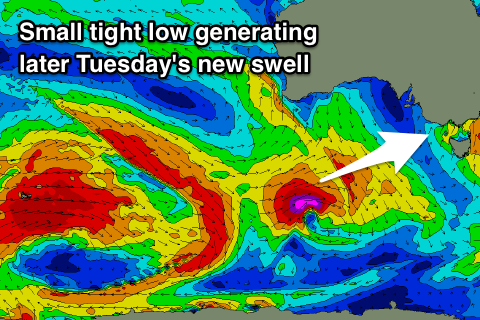
A tight and intense fetch of severe-gale to storm-force W/SW winds are forecast, weakening as quickly as they devlop south of the country.
Still a good spike in size to 3ft on the sets by dark Tuesday is due on the Surf Coast, with 4-6ft sets to the east with that hopefully favourable breeze. We'll confirm this Monday. The swell is due to ease from a similar size on Wednesday with winds from the northern quadrant.
Longer term smallish and inconsistent levels of background W/SW groundswell from the south-east Indian Ocean are due into the end of the week and weekend, but winds are a little unsure as a weak mid-latitude low moves across the country. At this stage we're probably looking at favourable winds for locations east of Melbourne, but more on this Monday. Have a great weekend!
Comments
Someone wake me when winter ends, this is getting unbearable
What!? A cold day in winter. Move to Queensland goof.
What coast do you live on mate?
The cold doesnt worry me one bit. It’s the day after day after farking day of howling onshore winds.