Easing surf with average winds, great Friday

Victoria Forecast by Craig Brokensha (issued Monday 28th March)
Best Days: Wednesday morning keen surfers around Torquay, small Surf Coast Thursday, Friday both coasts, Saturday morning Surf Coast
Recap
Great clean 3-4ft waves across the Surf Coast Saturday morning with offshore W/NW winds, tending more variable ahead of a mid-afternoon onshore change. The surf kicked a little into the afternoon as well with a new SW groundswell ahead of a large increase in size Sunday.
This large powerful long-period SW groundswell was generated by a very intense mid-latitude low aiming 50kt+ winds through Victoria's swell window.
Cape Sorell recorded strong numbers with Significant Wave Heights peaking over 6m at 16s, and this resulted in large 5-6ft+ waves on the Surf Coast and 8ft+ surf on the Mornington Peninsula. Conditions weren't too favourable though with only a short-lived period of lighter winds from the western quadrant on the Surf Coast with onshore S/SW winds everywhere else.
Today the swell has eased back to the 3-5ft range on the Surf Coast with S/SE onshores and 6ft+ on the Mornington Peninsula.
This week (Mar 29 – Apr 1)
Moderate amounts of reinforcing SW groundswell will continue into this afternoon and tomorrow morning, generated by a broad and elongated fetch of strong SW winds on the backside of the intense low generating yesterday's SW swell.
A slow drop in size is due through the day though, from 3ft+ on the Surf Coast and 5ft on the Mornington Peninsula, down further from 2-3ft and 4-5ft respectively Wednesday morning.
Conditions will remain average tomorrow with a moderate to fresh S/SE wind, more S/SW Wednesday. There's a good chance for an early W'ly on the Surf Coast Wednesday morning for keen surfers.
 A low point in swell activity is due Thursday morning with small leftover sets to 2ft on the Surf Coast and 3-4ft on the Mornington Peninsula under offshore NW winds.
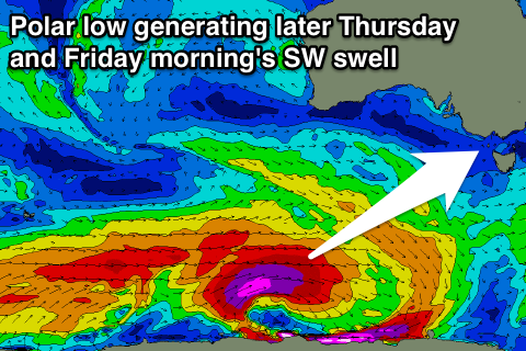
Into the afternoon a small increase in SW groundswell is due from a pre-frontal fetch of W/NW gales ahead of a much stronger polar low forming south-western of WA.
This swell may produce the odd bigger set to 2-3ft on the Surf Coast through the afternoon and evening with 5ft sets on the Mornington Peninsula. Winds will likely swing more W/SW into the afternoon, but without too much strength.
Of greater importance is a long-period and strong SW groundswell due off the polar low, with a fetch of severe-gale to storm-force W/SW winds forming in our south-west swell window.
The fore-runners of this swell should be seen into Thursday afternoon, but a peak is due Friday morning to a strong but slightly inconsistent 3-5ft on the Surf Coast and 6ft+ on the Mornington Peninsula.
Winds will be good for both coasts through the morning with a N/NW offshore (N'ly early east of Melbourne), tending more NW and variable into the afternoon as the swell eases.
This weekend onwards (Apr 2 onwards)
Friday's long-period SW groundswell will be just the beginning of a much broader and multi-staged frontal progression moving in from the west through the middle to end of the week under the influence of a strong node of the Long Wave Trough.
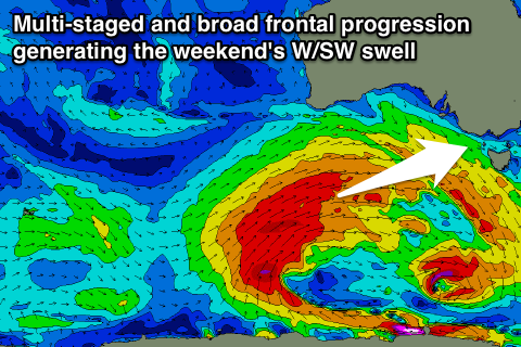 What we'll see is a secondary strong polar front forming on the back of the low, followed by successive fronts piggy-backing over the top, generating a mix of SW and W/SW groundswell pulses.
Size wise we should see swell magnets on the Surf Coast offer 3-4ft waves Saturday morning, building more to the 4-5ft range out of the W/SW into the afternoon, with the largest increase due Sunday to 4-6ft.
The Mornington Peninsula should build towards 6-8ft Saturday afternoon, peaking Sunday in the 6-8ft+ range.
Winds will be great for the Surf Coast Saturday morning with a NW offshore, but a W/SW change is due late morning followed by a building ridge of high pressure and unfavourable S/SE winds Sunday.
Comments
Craig thanks so much for these forecasts. Can confirm the extra pulse Sat arvo, we commented on it, wondering if that was the Sunday swell filling in.
Sunday was a sight to behold, went out with the young one in such size for the first time, he got a couple of crackers and seemed to thrive in it. You could see them darken the horizon a good minute out, some broke far outside and rolled through, some waited and really stood up inside. Big sweeps, big lineups. Multiple turns. Epic.
No worries at all, great feedback and it's always a great buz getting out into some more serious size. Keeps you on your toes and alive!
Cheers, Craig
Interesting to see what they will do now with the comp?
Will they keep going with these onshore conditions or hold off until latter in the week?
Maybe run as much as they can of the women's heats on Thursday with smaller clean conditions then run the men's Friday & Saturday.