Plenty of swell, best on the Surf Coast

Victoria Forecast by Craig Brokensha (issued Wednesday 23rd March)
Best Days: Friday morning Surf Coast, Saturday morning Surf Coast, early Sunday and Monday Surf Coast, Tuesday morning Surf Coast
Recap
A strong and powerful SW groundswell came in as expected yesterday with solid sets between 3-5ft across exposed breaks on the Surf Coast and 6ft to occasionally 8ft on the Mornington Peninsula. Conditions were best to the east with E/NE tending N/NE winds, while the Surf Coast beaches were the pick for a surf.
Today the swell's on the ease with clean conditions across all locations, easing from 2-3ft on the Surf Coast and 4-5ft on the Mornington Peninsula. Make the most of this morning as an onshore change is due this afternoon.
This week and weekend (Mar 24 - 27)
The first in a series of SW groundswell pulses is due to build tomorrow across both coasts, with it currently being generated to our south-west.
We should see the Surf Coast building to 3-4ft, with larger 6ft+ sets on the Mornington Peninsula, but conditions will be average with a moderate S/SE'ly.
The swell should drop back through Friday from 3ft+ on the Surf Coast (likely 3-4ft early at Bells) and 5-6ft on the Mornington Peninsula with a moderate SW breeze. The Torquay region however should see a morning W'ly, favouring the protected reefs.
The timing of the weekend's swell pulses have moved around a little, and Sunday now looks to offer the most size.
Firstly through Saturday we should see two separate pulses of SW groundswell, the first for the morning from a pre-frontal fetch of W/NW gales, with a stronger pulse into the afternoon from a post-frontal fetch of W/SW gales.
Saturday morning's should provide 3-4ft sets on the Surf Coast, with 5-6ft waves on the Mornington Peninsula, with better 5ft sets developing into the afternoon at swell magnets on the Surf Coast along with sets above 6ft on the Mornington Peninsula.
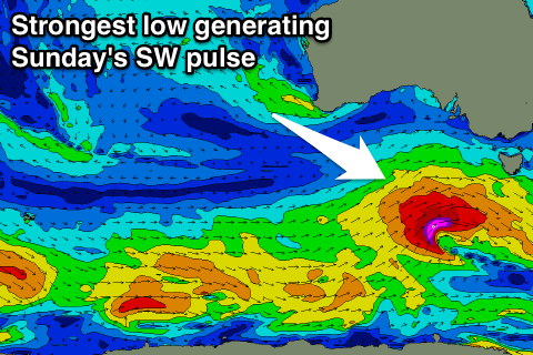 The largest SW groundswell will be generated by a strengthening mid-latitude racing in from the west during Friday and Saturday, aiming a fetch of severe-gale to possibly storm-force SW winds through our south-western swell window.
A longer-period and moderate to large SW groundswell should result, peaking Sunday morning to a solid 5-6ft across exposed breaks on the Surf Coast and 8ft on the Mornington Peninsula, easing slowly through the day.
Offshore NW winds are due Saturday morning ahead of a SW change early afternoon, with lingering SW winds into Sunday that should tend W/NW around Torquay through the morning.
Next week onwards (Mar 28 onwards)
Sunday's swell will continue to fade through Monday from 3-4ft on the Surf Coast and the 6ft range on the Mornington Peninsula with light to moderate S/SW winds. Torquay should again see early W/NW breezes, creating clean conditions.
The final frontal system in the progression through the end of this week and weekend should produce a weak fetch of strong SW winds through our south-western swell window Saturday and Sunday, producing a good reinforcing SW swell for later Monday and more so Tuesday morning.
3-4ft sets are due to continue on the Surf Coast, with 6ft sets to the east with morning NW winds.
Longer term a larger SW groundswell event for later in the week is still on the cards with a slow moving and very strong and vast polar frontal progression due to develop south-west of WA through next week. We'll have another look at this Friday though.
Comments
How much strength in this change you think? Everything west of otway is still reading mostly from the westerly quadrant under 10knots still?
Only relatively weak.. 10-15kt gusts.