Best Thursday, average until Monday

Victoria Forecast by Craig Brokensha (issued Wednesday 11th November)
Best Days: Thursday, possibly Saturday morning Surf Coast, exposed spots Monday morning
Recap
After an excellent day of surf on Monday with a strong building and inconsistent SW groundswell along with favourable winds basically all day, a strong onshore change killed any chance of a decent surf yesterday, as a secondary reinforcing SW swell filling in.
Today the swell was still hanging around, but hard to distinguish under persistent onshore winds, which will swing more E/SE through the day and strengthen.
This week and weekend (Nov 12 - 15)
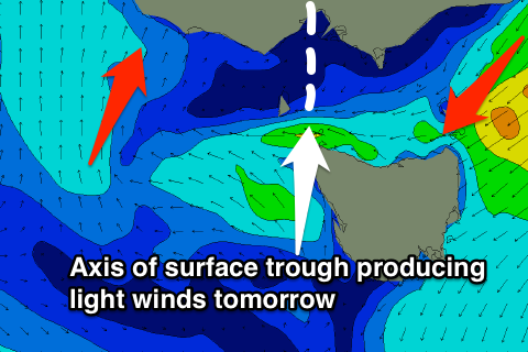 Tomorrow is still the pick of the week, with the axis of a surface trough currently dipping across the state due to move in, resulting in variable tending locally offshore winds through the morning, before a strengthening W/SW change moves in mid-late afternoon.
Today's SW groundswell should continue to provide fun sized waves tomorrow morning, easing back from 3ft at exposed spots on the Surf Coast and 5-6ft on the Mornington Peninsula.
Come Friday, the backside of the trough will be moving through with fresh S/SW tending SW breezes due along with a bottom out in swell. A good lay day.
Through Friday afternoon, a new W/SW groundswell pulse is due ahead of a stronger long-range W/SW pulse on Saturday.
The initial pulse Friday will be generated by a pre-frontal fetch of W/NW gales, ahead of the strong polar low generating Saturday's swell. This low has been generating a fetch of gale to sub-severe-gale-force W/SW winds through the south-east Indian Ocean, with the system now passing under WA while weakening and dipping towards Antarctica.
A good sized but inconsistent W/SW groundswell should be generated by this system, coming in at 3-4ft on the Surf Coast, with the odd bigger bomb likely at swell magnets like 13th Beach, while the Mornington Peninsula should see 6-8ft sets.
Winds are the main issue with a moderate to fresh SW'ly expected across the state, although there's a chance Torquay may see an early W/NW'ly, we'll have to confirm or disregard this on Friday.
As the swell eases Sunday winds look to remain dicey with lingering S'ly breezes across both coasts. There is a chance of lighter winds through the morning, but we'll have to look at this again on Friday.
Next week onwards (Nov 16 onwards)
Unfortunately there's nothing significant expected into early next week as a large blocking high deflects storms away from our swell window. Winds should improve for exposed spots Monday though with offshore N'ly winds expected and small easing levels of swell.
Some new W/SW swell is on the cards for mid-late week, but check back Friday for the latest on this.