Generally onshore, with possible small windows of hope

Victoria Forecast by Craig Brokensha (issued Monday 6th April)
Best Days: Possibly early Tuesday, Thursday morning Surf Coast, possibly Friday both coasts (more so east of Melbourne), both coasts Saturday morning
Recap
Small waves Saturday morning with lumpy/wobbly conditions under an early E'ly tending variable wind. A new inconsistent SW groundswell filled in through the morning though as conditions improved, providing good waves across the beaches and reefs on both coasts into the afternoon.
Sunday was great on the Surf Coast with a better swell to 3ft to occasionally 4ft under offshore winds, while the Mornington Peninsula was bumpy and average.
Today a secondary pulse has kept the surf up around a similar size on the Surf Coast and the Mornington Peninsula and light W/NW-NW winds have again favoured the Surf Coast while creating bumpy conditions on the Mornington Peninsula.
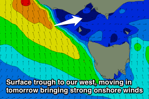
The swell and winds should remain good for the Surf Coast into the afternoon with only light sea breezes due as an intense surface trough stalls to our west.
This week (Apr 7 - 10)
The week ahead will continue to be a tricky one to forecast, but in general winds have taken a turn back for the worse for the Surf Coast and Mornington Peninsula.
An intense surface trough that's currently sitting to our west is now forecast to move in just before dawn tomorrow morning and with this we'll see strong S'ly winds aimed directly into the Surf Coast, possibly being lighter at dawn on the Mornington Peninsula before strengthening through the morning.
One of the models has the trough still just stalling at Cape Otway early tomorrow resulting in variable breezes and cleaner conditions around dawn, but you'll have to keep an eye on the local wind observations.
Surf wise, a good new SW groundswell is due to 3-4ft on the Surf Coast and 5-6ft+ on the Mornington Peninsula, but we'll also see plenty of S/SW swell from the trough, probably coming in at a similar size, if not a touch bigger.
A strong polar front that's currently south of WA should then generate another strong SW groundswell pulse for Wednesday, building to 3-5ft through the afternoon on the Surf Coast and 6ft to occasionally 8ft on the Mornington Peninsula.
A drop in size is then due into Thursday from 3-4ft and 6ft+ respectively while a smaller reinforcing SW groundswell should keep 3ft sets hitting the Surf Coast Friday with 5-6ft sets east of Melbourne.
The only issue is the local winds and they're expected to persist from the S'th Wednesday and lighter into Thursday morning.
There's the smallest of chances for an early W'ly around Torquay Wednesday but more so Thursday morning, although it will be short-lived and not worth the drive from Melbourne.
Friday is a little tricky to call with a funky surface trough sitting across the region, possibly resulting in morning variable winds, but we'll have to review this Wednesday.
Into the weekend we should see some fun S/SW groundswell Sunday and Monday but winds look to be an issue again as a cold front pushing up towards the Tasman Sea clips the east of the state bringing onshore S/SE winds. We'll have a closer look at this on Wednesday though.