Fading surf through the weekend
Friday, 4 July 2025
Fading surf through the weekend
Friday, 4 July 2025
Make the most of tomorrow morning with next week expected to be mostly small to tiny.
Make the most of tomorrow morning with next week expected to be mostly small to tiny.
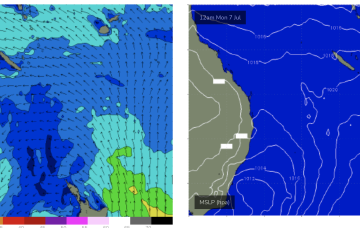
Weak high pressure is drifting up over NSW/QLD with a low in the Tasman moving away to the east as it weakens. No signicifant swell generating winds in the Coral Sea so surf is tiny/flat and likely to remain that way right through the weekend and next week.
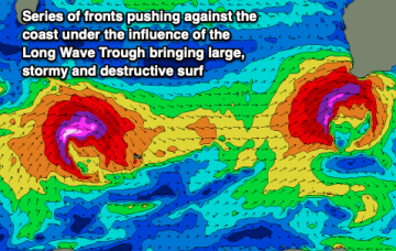
The trough is linked to a broad low which moves off the South Coast o/night Sun into Mon and does aim up some useful swell generating winds for NETas.
The weekend will offer small waves across both regions, with next week expected to be come large and windy across the Mid Coast.
The complex, coastal low is now dissipating and drifting towards New Zealand while high pressure drifts NE to sit over sub-tropical NSW/SEQLD tomorrow before entering the Tasman on Sunday with a broad low pushing across the interior of Victoria and NSW behind it.
The complex, coastal low is now dissipating and drifting towards New Zealand while high pressure drifts NE to sit over sub-tropical NSW/SEQLD tomorrow before entering the Tasman on Sunday with a broad low pushing across the interior of Victoria and NSW behind it.
Make the most of the exposed beaches over the coming days with mid-late next week looking tricky and not overly outstanding.
Active week of surf next week across all locations (from the weekend in the Maldives).
We have a relatively quiet week ahead of a series of severe systems hitting the state.
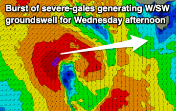
Gales to severe gales from the S through SE will generate another peak in size later today and through tomorrow from the secondary low slingshotting around the primary centre, well positioned in the Tasmanian swell window. Winds from the E-E/NE are also still active in the swell window.