Small weekend, with building surf and wind next week

South Australian Forecast by Craig Brokensha (issued Friday July 4th)
Best Days: South Coast today and tomorrow, Mid Coast Sunday, South Coast Monday morning, South Coast Wednesday morning, Friday both coasts (morning Mid Coast)
Features of the Forecast (tl;dr)
- Easing S/SW swell tomorrow with mod-fresh N/NE tending weaker N/NW winds
- Small, low period W'ly swell Sun with E/NE tending light NW winds
- Small mid-period SW swell Mon with strengthening N/NW winds
- Building stormy windswell across the Mid Coast Tue with strong N/NW tending W/NW-W winds
- Larger W/SW groundswell Wed with strong N/NW tending NW then W/NW winds
- Mix of large swells Thu with strong SW winds
- Cleaner conditions with fun swells from Fri through the weekend
Recap
Yesterday was great across the South Coast with the swell holding the 3ft range through the morning under a moderate offshore wind. The swell eased slowly into the afternoon as winds held, while the Mid coast was tiny and slightly wind affected.
This morning the South Coast is clean again but smaller and to 2ft or so.

Stackes sets and great conditions yesterday morning
This weekend and next week (Jul 5 - 11)
Small levels of S/SW swell that are holding 2ft across the Middleton stretch today should persist tomorrow morning before fading into the afternoon and dropping back to 1-2ft Sunday morning.
A small lift in localised W/SW-SW swell that was flagged on Wednesday, generated by a small low moving in from the west now looks to be non existent for the South Coast, but the Mid Coast should see a fetch of strong W/SW winds generating a pulse to 2ft Sunday.

Coming back to the local winds tomorrow will be see moderate to fresh N/NE tending weaker N/NW winds, favouring the South Coast all day with Sunday seeing workable E/NE tending NW winds on the Mid Coast as the low moves north of us, NW tending SW down South.
Into Monday, our small lift in mid-period SW swell is on track, generated by a weak polar front moving under the country today and tomorrow. This should provide 2ft+ waves across Middleton with the Mid Coast expected to fade back from Sunday as winds strengthen from the N/NW.
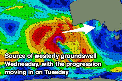
Now, moving into Tuesday, things get a little more interesting.
A strong node of the Long Wave Trough is expected to develop across Western Australia, steering strengthening polar frontal activity up and across the region. An initial couple of strong systems developing this weekend will generate fetches of severe-gale W/SW winds through our western swell window, still maintaining strength through the Bight before passing across us on Tuesday.
We’ll see a mix of lower period, stormy swell building through Tuesday under strong N/NW tending W/NW then W winds, with the groundswell due to peak through Wednesday, mixed in with the leftovers from Tuesday's swell.
A secondary strong front approaching from the west will generate an additional increase in windswell later but more so for Thursday, along with a secondary pulse of groundswell into the afternoon.
For the South Coast the earlier stages of the frontal progression, south-west and south of Western Australia looks to generate the most size for Wednesday, easing back temporarily, possibly Thursday morning before kicking later with the new groundswell.
The models diverge a little on the structure of the coming progression once on our doorstep so check back Monday for a more accurate idea on sizes for both regions.
As a guide, the Mid Coast on Tuesday looks to build to a stormy 3ft+ into the afternoon with Wednesday coming in at 3ft or so, increasing a little more to 3-4ft later if not Thursday morning.
The South Coast Tuesday will only see a small and late increase in mid-period swell with Wednesday likely revealing better 3-5ft sets, down a touch Thursday.
Local winds on Wednesday will favour the South Coast, strengthening from the N/NW tending NW, then W/NW later, with us falling in behind the tail of the frontal progression Thursday, resulting in strong but easing SW-S/SW winds.
Next weekend also looks promising with northerly winds and some moderate sized SW groundswell on the cards. More on this Monday, have a great weekend!
Comments
coorong looks super full and healthy.. Studio Ghibli millpond mirror finish today.
re algae bloom, Meningie locals aren't worried about their lake,
(according to locals at the Meningie Hotel),
though the lady who cooks at the Waterfront
isn't serving mullet cos she thinks it tastes and smells funny
(well, funnier than usual) lately : /
(had a fun flap about on Long Beach
on that fat little sanctum fish @seeds,
3rd ramp area's banks are just destroyed!)
15 degrees and burning sun today : o
can this dogshit algae even live in fresh water?
(cheers @tubeshooter, btw, I stopped at a little 2nd hand shop in Meningie today, and chuckled as I bought a righteous CD for the drive to Radelaide.. $3 "Straight Outta Boone County".. I'd play it to you on the interwebs, but it is clearly too country-niche and special to be webified.. (it is actually pretty excellent) I'll post it to @seeds for when he gets home : )
How is JBay looking for the comp? Looking at the free charts online it looks as though Saturday will be very very solid?
Will have a forecast tomorrow. Looks good to start. Not overly big.