Tiny spell ahead, though plenty on the charts next week

Sydney, Hunter and Illawarra Surf Forecast by Ben Matson (issued Wednesday 22nd May)
Best Days: Thurs AM: small easing leftover S'ly swell. Mon: small E/NE and S'ly swell combo. Wed/Thurs next week: building S'ly swell, possibly large.
Recap: Flukey long period south swells delivered plenty of waves on Tuesday, building from 3ft at south facing beaches to 4-5ft throughout the day, with bigger sets pushing 6ft observed at some reliable swell magnets well north (and well south) of the CBD. Winds were light so conditions have been clean. Size maintained 3-4ft at south facing beaches this morning though it's eased back this afternoon. Conditions have remained clean with light winds.
This week (May 23 -24)
Today’s Forecaster Notes are brought to you by Rip Curl
The Southern Ocean storm track is aimed well and truly away from our swell window, so we’re not expecting much, if any new energy for the rest of the week.
Today’s south swell will gradually abate in size over the coming days, and with light winds both days we’ll see small clean options across the swell magnets at best. Aim for early Thursday for the most potential as it’ll be pretty small by the afternoon and into Friday. DOn't expect much action away from south facing beaches either.
This weekend (May 25 - 26)
Model guidance has a series of small long period S’ly swells glancing the region over the weekend, but I don’t think we’ll see much energy in our neck of the woods, as it will have been sourced from strong though poorly aligned fronts below the continent this week. If you pick up a stray waist high wave at a swell magnet I’d be pleasantly surprised.
A small E/NE swell may lift surf size slowly (from a tiny base) over the weekend too, originating from a small easterly dip developing south of Fiji. However, at this stage only late Sunday afternoon has the most size potential for a few inconsistent 2ft sets. Expect much smaller surf prior to then.
Conditions will be first class both days with freshening W/NW tending NW winds.
Next week (May 27 onwards)
The E/NE swell arriving late Sunday has been perked up ever so slightly in the latest model runs, but given the still-relatively modest surface wind speeds, I’m reluctant to nudge wave height estimates above 2-3ft for Monday. As such I’ll keep the forecast pegged there for now and re-evaluate in Friday’s notes. If we see any swell from this region, it'll be very slow and inconsistent too, so don't go moving the diary around.
A strong front will cross NSW on Sunday night, but it’ll be generally too far north in latitude for us to see any south swell - an increase is expected on Monday though at this stage I’m expecting only 2-3ft sets across south facing beaches into the afternoon (smaller earlier), and 3-4ft in the Hunter (and smaller south from the Illawarra due to the short fetch length and alignment). Even that’s a little optimistic at this stage.
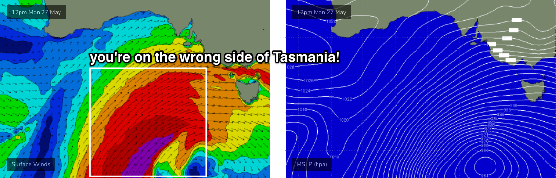
A much stronger low will develop south-west of Tasmania at the same time, but current indications are that it’ll reach peak intensify on the wrong (western) side of the apple isle (see below). If the models shunt this system ten degrees to the east, we’d be looking at a 15ft+ south swell, but current indications are for the low to weaken as it enters our swell window, resulting in 3-4ft surf around Wednesday building to 5-6ft on Thursday.
It’s still early days though, so check back Friday for the latest outlook. This is a dynamic winter system and it's going to generate very large surf for somewhere early-mid next week.
Comments
What a run of fun waves. Need a few days off to get back into positive points territory with the missus..
Amen
I hope I'm somewhere early mid next week
How close is this tiny low/trough off Sydney and the South Coast to giving us any swell?
Looks like there’s a semi-stationary fetch that is a couple 100kms blowing for 24h at 12-15 knots.
How weak is too weak?
Really gotta be 20kts at least to generate anything meaningful.
Any super rough guestiates for the first weekend in June? in Sydney?
cheers