Poor weekend, strong swell next week

Southern Tasmanian Surf Forecast by Craig Brokensha (issued Friday December 8)
Best Days: Sunday morning beginners, Tuesday, Wednesday morning
Features of the Forecast (tl;dr)
- Tiny tomorrow with developing strong S/SW winds at dawn
- Tiny SW windswell Sun AM with W/NW tending S/SE winds
- Building mid-period SW swell Mon with W tending strong S/SW winds
- Large SW groundswell peaking Tue AM with N/NW tending S/SE winds
- Steadily easing S/SW swell Wed with variable tending SE winds
Recap
Tiny, clean conditions yesterday morning and this morning, ideal for beginners.
This week and weekend (Dec 9 - 15)
The weekend will be poor with no major surf and a trough will bring a strong S/SW change tomorrow morning, with lighter W/SW winds at dawn but no size.
A tiny 1-1.5ft of windswell is likely from these onshore winds Sunday morning, and winds are due to shift W/NW for a period ahead of sea breezes.
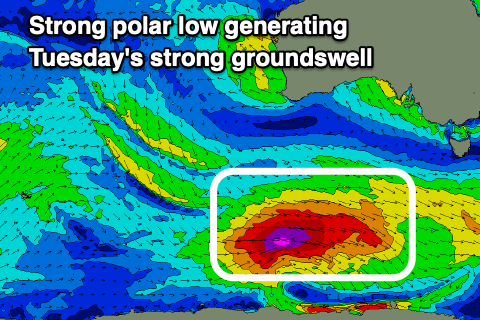
Moving into next week, we've got a much more significant swell due, generated by a deepening polar low to the south-west of Western Australia today. A fetch of severe-gale W/NW tending W winds will project east on the weekend, and then east-northeast under us on Monday.
This will bring a building mid-period swell on Monday with W tending strong S/SW winds, while the swell is due to peak Tuesday as winds ease and tend light N/NW in the morning ahead of sea breezes.
Size wise, this swell is quite significant but the direction looks more SW than S/SW, peaking in the 6ft range across Clifton Tuesday morning, easing steadily thereafter and down from 3ft+ on Wednesday morning.
Following this, a small reinforcing pulse of mid-period SW swell may be seen later week to 2ft or so, but with dicey winds. More on this Monday. Have a great weekend!