Great swell Sunday but with light onshore winds

Southern Tasmania Forecast (issued Friday 13th June)
Best Days: Sunday, Monday, Thursday for small inconsistent waves
Recap
Tiny waves continued through yesterday and today, but a slight increase in long-range and very inconsistent W/SW groundswell should have been seen this afternoon.
This weekend (Jun 14 - 15)
Tomorrow will be worth giving a miss or hitting up the East Coast as this afternoon's slow W/SW groundswell is due to ease as early light winds give way to a strong S'ly change.
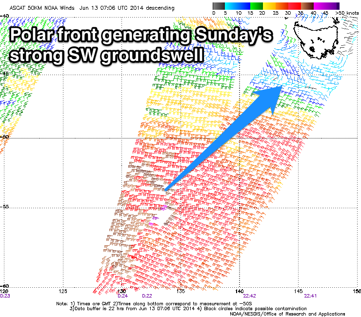 A late increase in new strong SW groundswell is due across Clifton tomorrow ahead of a peak Sunday. This swell has and is still being generated by a vigorous polar front sliding along the polar shelf before pushing slightly more north-east towards us today.
A strong 3-4ft+ swell is due across Clifton Sunday morning ahead of a drop into the afternoon and further Monday from 2ft. Winds as touched on in Wednesday's notes don't look ideal with a light SE'ly expected to tend variable and then around to the SW into the afternoon. Still there should be plenty of fun waves on offer with the strength of the swell.
Next Monday onwards (Jun 16 onwards)
As touched on above, the swell will drop considerably overnight Sunday leaving 2ft waves across Clifton early with NW winds ahead of a late change, but this might not arrive until after dark.
No considerable swell is due from then onwards though, with the storm track remaining unfavourably aligned for us. In saying this we should see tiny waves through Tuesday and Wednesday with a possible slight pulse to 1-2ft Thursday but we'll review this Monday.