Back to back large swells for the South Arm, first from the S/SW and then second from the S/SE

Southern Tasmania Forecast (issued Monday 5th May)
Best Days: Tuesday and Wednesday in protected spots, Thursday
Recap
The weekend saw building levels of S/SE windswell along with poor conditions. Sunday offered the most size to 3-4ft and with workable winds for selected locations but it wasn't enough to get some locations working.
Today the swell has eased back from 2ft under better offshores, but a fresh SW change has since moved through.
This week (May 5 - 9)
Well tomorrow is looking quite interesting indeed!
There's been no real change to the outlook across the South Arm tomorrow, and if anything we've got a slight upgrade in the size due across the coast.
Currently an intense low just to our south-west is generating a fetch of gale to severe-gale SW winds right in our swell window. This low will then project favourably up into us tomorrow, travelling at a similar speed to the swell its creating resulting in a 'captured fetch' scenario.
This should produce a large and powerful SW tending S/SW groundswell tomorrow that's expected to peak through the middle of the day/afternoon to 6ft+ across Clifton. Winds will be strong from the SW tending S/SW favouring protected locations..
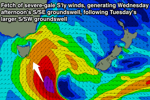 The swell will drop back into Wednesday as the low moves further east, but a secondary fetch of S'ly gales wrapping around the lows southern flank tomorrow (pictured right) should generate a reinforcing and rare S/SE groundswell for the afternoon and Thursday morning.
Size wise, Clifton should see strong 4-5ft sets into Wednesday afternoon before easing from 3-4ft Thursday. Exposed spots to the S/SE swell will see larger waves but SW winds will again limit options for protected locations.
Thursday should be cleaner across Clifton with an offshore NW tending variable breeze.
This weekend onwards (May 10 onwards)
There's nothing major on the cards for the weekend with the coast expected to bottom out under fresh N'ly winds Saturday ahead of a change on Sunday.
A new long-range W/SW groundswell is due later Monday before easing Tuesday but not above 2ft across Clifton. We'll review this again on Wednesday though, in the meantime plan around the strong swells due over the coming days.