Trickier period with varying winds

South Australian Surf Forecast by Craig Brokensha (issued Monday June 26th)
Best Days: Today both coasts, South Coast tomorrow, Friday protected spots South Coast, Saturday and Sunday mornings South Coast
Features of the Forecast (tl;dr)
- Easing mid-period swell tomorrow with moderate N/NW tending NW winds
- Low point in swell early Wed with W/NW tending SW then stronger S winds
- Moderate sized mid-period S/SW swell building Wed, peaking Thu with mod-fresh SW winds
- Similar sized, reinforcing swells for Fri/Sat
- Strong W/NW winds Fri, W/NW tending SW then S on Sat
- Easing surf Sun with NE tending SE winds
Recap
Small, clean surf across the South Coast Saturday with choppy, building windswell waves across the Mid Coast out of the NW.
Yesterday offered larger, stormier surf in the gulf as strong NW winds persisted, a little too west for Middleton but fun on the right boards for the keen and biggest through the afternoon.
This morning conditions are cleaner with an easing swell from the 2ft range across the Mid Coast with weaker onshore winds, fun down South and to 2-3ft off Middleton, bigger towards Goolwa but more wind affected.
This week and weekend (Jun 27 – Jul 2)
The coming period isn't as favourable as it has been with onshore winds due to move in with the next swell episode through the mid-late week, while it'll be on the tiny side for the Mid Coast.
Today's mid-period SW swell is due to ease back through tomorrow but conditions will be great with a moderate N/NW tending NW breeze and easing 2ft to possibly 3ft sets across Middleton, better on the swell magnets. The Mid will be a touch cleaner with a N/NE breeze but tiny and best for learners.
Wednesday morning will see a temporary low point in swell along with an early W/NW breeze before shifting SW by midday and strengthening from the S'th into the afternoon as a trough clips us.
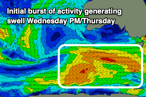
This trough will be associated with a broad but weak Southern Ocean frontal progression firing up today to the south of Western Australia.
Overall there'll be no major wind speeds within the progression but we should still see good fetches of back to back fetches generating some fun sized, mid-period S/SW swell.
The first increase is due Wednesday afternoon but with those poor winds, peaking Thursday to 3-4ft across Middleton with 1ft sets on the Mid Coast. Winds look to swing SW through Thursday, being moderate to fresh in strength and only a slim chance of early W/NW breezes around Victor.
Friday will be better with W/NW winds and some reinforcing levels of mid-period swell to 3-4ft from the next front pushing towards Victoria later week.
Winds will deteriorate again on Saturday, early W/NW and then swinging to the S/SW through the day with the next trough and yet another pulse of similar sized, mid-period swell Saturday, easing Sunday.
The Mid Coast will remain tiny, and NE winds on Sunday should provide better options as the swell starts to drop away.
Longer term the surf will ease into early-mid next week ahead of some fresh mid-latitude frontal activity and W/SW swells mid-late week. More on this Wednesday.