Onshore winds creating problems at Victor, small opportunities on the Mid

South Australian Surf Forecast by Ben Matson (issued Wednesday 3rd May)
Features of the Forecast (tl;dr)
- Onshore conditions down south for the next four days
- A few small waves on the Mid this weekend with occasional periods of S/SE winds
- Tues/Wed has potential for the Mid with a new swell
- Improving surf down south Wed, looking great (though small) Thurs/Fri
Recap
The Mid's been pretty small and average for the last few days, but Victor saw improving conditions on Thursday with solid though easing swells. Today has been small and clean with freshening offshore winds.
This weekend (May 6 - 7)
We've got four days of onshore winds ahead for the South Coast.
A cold front will cross the region this afternoon, and this will kick start proceedings. It's a real shame too as there's a decent groundswell inbound from the front on the synoptic chart below; size should build to a solid 4ft at Middleton and there'll be plenty of waves at most spots both days. Just keep your expectations low.
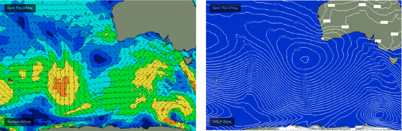
As for the Mid, this front isn't lining up perfectly within the swell window but it should be enough to generate a couple of feet of surf on the more favourable parts of the tide both days.
The overal synoptic flow will be sideshore from the south, but we should see pockets of early S/SE winds allowing for window of clean-ish conditions.
Nothing special but certainly worth a look.
Next week (May 8 onwards)
A strong front will cross Tasmania on Monday, clipping the South Oz coast and bringing about a fresh resurgance of SW winds for the afternoon. There's an outside chance for a period of light W'ly winds down south just prior to its arrival, but if the models speed up its passage over the weekend, this window may indeed close up.
Anyway, we'll be on the backside of the weekend's swell event so on the balance it's not worth getting too excited about.
Monday morning should remain clean on the Mid under early SE winds though we'll have only small leftover swell on tap.
Late in the day, the leading edge of a new groundswell may start to show at the CdC buoy, though Tuesday is a much better bet for this energy to appear. It'll have been generated in our distant swell window by an impressive fetch trailing a polar low at very southerly latitudes.
Locally, persistent onshore winds will marr surface conditions at Victor (size should rebuild to 4ft at MIddleton) however I'm most interested in the Mid Coast where we could see inconsistent though fun 2ft sets into Tuesday afternoon. Wednesday also has similar potential, though let's wait and see how the synoptics line up over the weekend.
The long term outlook suggests an extended run of small surf best suited to exposed coasts, with a large blocking high in the Bight deflecting Southern Ocean fronts away form our primary swell window, whilst maintaining favourable winds for Thursday and Friday at least.
Further frontal activity through the Bight beyond this holds some potential for short range energy on the MId into next weekend and the following week, but we'll assess that in more detail on Monday.
Have a great weekend!
Comments
Kawabunga