No change to the outlook

South Australian Surf Forecast by Craig Brokensha (issued Friday January 20th)
Best Days: No good days, possibly super keen Monday morning but more so Wednesday morning next week down South
Features of the Forecast (tl;dr)
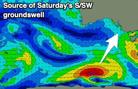
- Building S/SW groundswell Sat with fresh S/SE winds, strengthening through the day
- Easing mix of swells Sun with moderate-fresh SE winds, strengthening through the day from the S/SE
- Easing S/SE windswell Mon with light SE winds ahead of S/SE sea breezes
- Fading surf Tue with variable tending S/SE winds
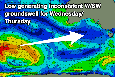
- Inconsistent W/SW groundswell building Wed
- Variable winds ahead of a strong S'ly change later morning
Recap
Our new mid-period SW swell seen into Wednesday afternoon and evening held well across the Mid Coast yesterday with 1.5ft waves once the early big tide receeded, clean most of the day. The South Coast was sizey but a mess with strong onshore winds.
Today the Mid is clean but tiny, while the South Coast has seen a slight improvement in conditions with a shift to E winds but the surf was still very lumpy and all over the place.

Fun waves yesterday once the tide dropped
This weekend and next week (Jan 21 - 27)
Unfortunately this morning was the only window for a half decent wave across the South Coast, with high pressure set to dominate our swell windows to the west, while an inland trough squeezes pressure gradients from the east.
This will bring a return to fresh S/SE winds tomorrow, strengthening through the day, then moderate to fresh SE on Sunday before strengthening again through the afternoon.
Swell wise, some localised windswell mixed in with a moderate sized S/SW groundswell are due with surf to 3ft from later morning tomorrow, tiny to flat on the Mid Coast.
Winds are due to abate through Monday with a lighter SE'ly expected along with a weak mix of easing swells from 2ft+ across Middleton. It won't be great at all and only for the super keen.
There's a chance for more variable winds on Tuesday morning, though likely lingering from the S'th but with no swell. We're due to see a low point in energy and 1-2ft of S/SE windswell across Middleton.
Wednesday should offer a window of cleaner conditions and small surf next week with variable breezes ahead of another trough moving in from the west, bringing S'ly winds into the afternoon, holding Thursday.
Swell wise, an inconsistent W/SW groundswell is due, generated by a strong but very distant polar low that's currently weakening in the Heard Island region. Due to the large distance between the source of the swell and our regions, there'll be long waits between sets but we should see small 2ft waves in the morning, building to 2-3ft through the afternoon but with the strengthening S/SW winds. The Mid Coast may see tiny 1ft sets.
Unfortunately there's nothing significant due into the longer term but we'll have a closer look at this on Monday. Have a great weekend and maybe plan a hike!