Little peaks on the South Coast, with some fun Mid swell

South Australian Surf Forecast by Craig Brokensha (issued Friday January 6th)
Best Days: Keen surfers tomorrow morning on the South Coast magnets, Mid Coast Monday, Tuesday and Wednesday morning
Features of the Forecast (tl;dr)
- Peaky, fading surf tomorrow with N/NE tending fresh SE winds, tiny Sun with N/NE tending S/SW winds
- Moderate sized W/SW swell for Mon, with a secondary slightly stronger pulse Tue
- Gusty S/SE-SE winds both Mon and Tue
- Easing surf Wed with fresh SE tending S/SW winds
- Smaller Thu with S/SE winds
Recap
No let up in the onshore winds across the South Coast and we've now got brown flood water spreading into the Victor Harbor and further west regions. It looks to have also led to some mortality of the local sea organisms. The Mid Coast was tiny and best for beginners yesterday, near flat today.

Brown town
This weekend and next week (Jan 7 - 13)
Looking at the weekend ahead and there's not much to get excited about. Conditions will become much cleaner across the South Coast but the swell will leave the building, thanks to a blocking setup seen through the week in the Bight.
Middleton looks to fade from 1-2ft tomorrow morning, likely a touch bigger on the magnets and a light to moderate N/NE wind will create smooth, peaky conditions ahead of SE sea breezes. The Mid will be flat.
Sunday looks tiny down South and conditions will be clean again with a N/NE offshore before a trough brings a S/SW change into the mid-afternoon.
This trough will unfortunately bring a reset back to gusty S/SE-SE winds on Monday and Tuesday as a strong high pushes in from the west behind it. This will create poor surf down South but create cleaner conditions in the gulf.
Luckily we've got some fun mid-period W/SW swell on the way from Monday, peaking Tuesday.
An initial pulse of small W/SW mid-period energy will be generated by a burst of strong W/SW winds passing under WA today and this evening, with sets to 2ft due through the day on the favourable parts of the tide.
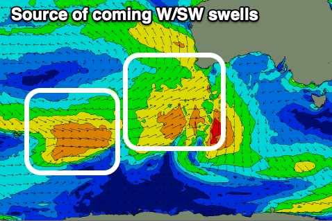
A secondary slightly stronger fetch of W/SW winds will then generate a secondary pulse of W/SW swell for Tuesday to a similar 2ft, with the possible bigger one on the favourable parts of the tide.
Those local S/SE-SE winds will create good conditions, while the South Coast will be poor.
A slow easing trend is due through Wednesday and Thursday as winds shift more SE and ease on the morning of the former, reverting back to the S/SE on the latter.
Unfortunately there's no significant swell due late week and into the weekend as winds slowly shift more E/SE. So make the most of coming days of small surf. Have a great weekend!