Not much to work with down South, with the Mid Coast tiny until next week

South Australian Surf Forecast by Craig Brokensha (issued Wednesday January 4th)
Best Days: Mid Coast for the keen this afternoon, South Coast for the keen Saturday morning, Mid Coast late Monday, Tuesday and Wednesday morning
Features of the Forecast (tl;dr)
- Easing mix of W/SW and S/SW swells tomorrow with strong SE tending S/SE winds
- Smaller surf Fri with moderate E/SE tending S/SE winds
- Peaky, fading surf Sat with N/NE tending SE winds, tiny Sun with NW tending S/SW winds
- Inconsistent W/SW groundswell Mon with mod-fresh S/SE tending strong S/SW winds, then S/SE later
- Better mid-period W/SW swells Tue with mod-fresh SE tending stronger S/SE winds
- Smaller Wed with E/SE tending S winds.
Recap
Poor surf across the South Coast, but a reinforcing pulse of W/SW swell energy across the Mid Coast provided fun, bumpy 1-2ft sets through the afternoon, smaller this morning and back to 1-1.5ft on the full tide. We should see slow 1-2ft sets persist this afternoon as winds strengthen from the S/SE.

Good sets yesterday PM
This week and next (Jan 5 - 13)
A mix of W/SW and S/SW swells are breaking across the state right now and we'll see both ease through tomorrow as winds shift more SE but remain strong across the South Coast. This will create poor conditions while the Mid Coast will be clean but tiny.
Winds should start to improve on Friday across the South Coast, easing and tending E/SE but size wise, there'll only be a small mix of background S/SW swell to 2ft with some local S/SE windswell.
Moving into the weekend we'll see the size and energy continue to drop as winds improve further, swinging light N/NE. Unfortunately we'll be looking at fading 1-2ft sets max across Middleton, with 2ft+ sets on the magnets.
Sunday will be clean again but smaller with tiny waves left on the Surf Coast.
Looking at next week we've got a few pulses of W/SW swell due across the Mid Coast and winds from the south-eastern quadrant will favour the gulf waters while creating poor conditions down South.
The first and smallest swell will be a W/SW groundswell due Monday, generated by a small tight low forming south-west of Western Australia tomorrow. A burst of W/SW gales should generate 1ft to possibly 2ft sets but with moderate to fresh S/SE tending stronger S/SW winds in the wake of a trough and change Sunday evening. Winds should go back to the S/SE again later.
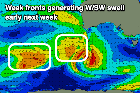
Better, more consistent pulses of mid-period W/SW swell are due Tuesday and Wednesday, generated by follow up mid-latitude fronts producing fetches of strong W/SW winds. The second of these front should produce the most size with Tuesday coming in at a more consistent 2ft, easing Wednesday from 1-2ft.
Winds should slowly swing more S/SE-SE on Tuesday, strong S/SE into the afternoon with lighter E/SE winds Wednesday morning.
Conditions will start to improve across the South Coast from Wednesday but more so Thursday though it looks like the swell will be on the way out again.
Longer term we may see small levels of mid-period W/SW swell arriving next weekend but more on this Friday.