Poor surf until next week

South Australian Surf Forecast by Craig Brokensha (issued Wednesday August 7th)
Best Days: Tuesday next week down South
Features of the Forecast (tl;dr)
- Small, inconsistent W/SW groundswell for later today, peaking tomorrow with moderate W/NW-NW winds
- Building SW windswell Fri with strong W/SW tending SW winds (possibly W/NW early in Victor but tiny)
- Easing SW windswell Sat with SW tending S/SW winds
- Tiny Sun with W/SW-SW winds
- Moderate sized mid-period S/SW swell Mon with moderate S/SW tending S winds
- Easing S swell Tue with NE winds
Recap
Fun, peaky conditions yesterday morning with easing sets from 2ft across Middleton, tiny to flat on the Mid Coast, tiny today down South but cleaner on the swell magnets.
We may see a tiny pulse of inconsistent W/SW groundswell later today on the Mid with it hitting the Cape du Couedic wave buoy, but keep your expectations lowered.
This week and weekend (Sep 8 - 11)
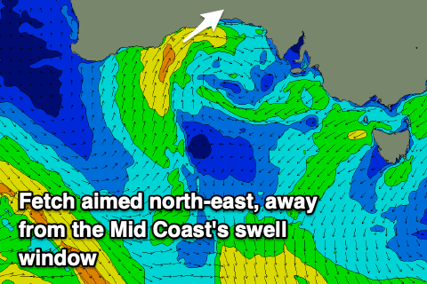
The end of the week's forecast revolved around the mid-latitude low that's currently south of Western Australia and as is mostly the case, ECMWF (the European weather model) won the day and we're looking at a less favourable swell producer as the low tracks too far north, with any swell generating fetch being blocked by the Eyre Peninsula.
Currently there's a slim fetch of W/SW winds aimed towards us, but we'll see this fetch swing SW and be aimed away from us as the low moves east.
 This will result in NW-W/NW winds tomorrow, moderate in strength with an inconsistent W/SW groundswell to 1-1.5ft on the favourable parts of the tide across the Mid Coast. The South Coast will be clean but remain tiny and to 1-1.5ft across Day St-Goolwa.
Come Friday the low is due to drop south and move into our swell window, bringing local fresh SW winds but only a very low quality, building SW windswell to 1-2ft on the Mid Coast and 2-3ft on the South Coast into the afternoon.
Conditions will be poor in any case with strong W/SW tending SW winds (likely W/NW early around Victor but tiny)
Unfortunately lingering SW winds will create average conditions Saturday with the windswell easing back in size, smaller Sunday with W/SW-SW winds.
A new pulse of moderate sized S/SW swell is on the cards for Monday but again the models diverge on the strength of the low linked to it. ECMWF is weaker and more likely, with a fetch of strong to sub-gale-force S/SW winds being projected north towards us, attached to a low originating from polar latitudes.
Sets to 4ft are due across the South Coast Monday but with poor S/SW tending S winds, easing Tuesday with more favourable NE winds as a high quickly moves in from the west. This looks to be the pick of next week with peaky, easing sets from the 3ft range. The Mid Coast looks to only reach 1ft owing to the southerly angle of the swell.
The end of the week looks slow owing to the blocking effects of the high, but a strong mid-latitude frontal progression pushing across Western Australia Tuesday should bring some new W/SW swell later week. More on this Friday when the models will hopefully be more aligned regarding the incoming storm activity.
Comments
Urrrrrgh!!
Sorry Stef.
For Sale - entire 2022 quiver. Brand new, never surfed...