Welcome, lighter winds for the weekend

South Australian Surf Forecast by Craig Brokensha (issued Friday January 8th)
Best Days: South Coast Saturday and Sunday mornings, South Coast Monday until the change hits, possibly dawn Wednesday morning down South (too full on the Mid)
Features of the Forecast (tl;dr)
- Easing, weakening swell on the weekend with light, favourable winds each morning
- Fun S/SW swell Mon with offshore winds until mid-afternoon
- Slightly bigger SW swell Wed but with variable tending onshore winds
Recap
Large, though messy, choppy surf for the South Coast yesterday morning with fresh SE winds, while the Mid Coast was tiny early, but kicked nicely with the push in tide, offering 1.5ft'ers. Today the swell is hanging in on the Mid with early 1-1.5ft sets, while the South Coast has eased with slightly cleaner conditions with a drop in the onshore breeze.
This weekend and next week (Jan 8 - 15)
After the poor run of conditions across the South Coast, most will be pleased that each morning over the weekend should provide lighter, variable winds and cleaner conditions for a surf.
The current S/SW groundswell will continue to ease in size and power through the weekend, easing from 2ft to occasionally 3ft across Middleton tomorrow morning, back to 1-2ft Sunday morning. Exposed beaches should be a touch bigger, though not too much owing to the south direction of the swell. The Mid will be tiny to flat.
Winds tomorrow morning should be variable until late morning, creating improving, fun conditions as the lumpiness and morning sickness irons out, becoming bumpy thereafter with freshening sea breezes.
Sunday looks similar with variable tending light N/NE winds with afternoon sea breezes likely holding off a little longer than Saturday.
Moving into Monday and our new, fun though inconsistent mid-period S/SW swell is on track, as are the fresh offshore N/NE tending N/NW winds, tending NW mid-afternoon ahead of a strong SW change by late afternoon.
The mid-period swell was generated by a polar front that's currently south-southwest of Western Australia. A pre-frontal fetch of strong W/NW winds will be followed by similar strength W/SW winds, producing a SW swell Monday, tending more S'ly Tuesday.
Size wise, it looks to come in at mostly 2ft across Middleton, with the odd 3ft'er in the mix, with the Mid Coast remaining tiny. Tuesday will then be poor with fresh SE winds in the wake of Monday afternoon's change and similar sized surf.
Looking at Wednesday and we've got a slightly better outlook for the Mid Coast, with a relatively weak but sustained frontal system that will form east of the Heard Island region this evening, due to generate a strong to near gale-force W/SW fetch in our south-western swell window, before projecting slightly north on Sunday, with a weaker fetch of SW winds produced in the Mid's swell window.
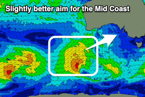 The remnants of this front will bring Monday's change, with the swell due to fill in Wednesday with tiny 1-1.5ft waves across the Mid Coast, possibly hitting 2ft on the magnets working the favourable parts of the tide (though the cycle looks unfavourable), and coming in at 3-4ft across Middleton. Winds are tricky with another trough in the region but dawn variable winds look to swing S/SW through the day, S/SE-SE on Thursday as the swell eases.
There may be another small pulse of SW swell to end the week but with S/SE-SE winds for the South Coast. We'll look at this closer Monday. Have a great weekend!
Comments
Apologies if this is obvious but what is meant by 'on the magnets'?
Tilly. There are 2 massive magnets under water / when old mate feels like it he flicks the switch to create the waves -
Swell magnets. Some of the mid coast reefs pick up the swell a bit better than others, but that is also tide dependent.