Surfing is back on the menu

South Australian Forecast by Craig Brokensha (issued Friday 20th November)
Best Days: Saturday morning South Coast, keen surfers Mid Coast Sunday afternoon, Mid Coast Monday morning, South Coast Wednesday morning, Mid Coast late week
Recap
A strong and good pulse of W/SW groundswell filled in yesterday across the state with bumpy conditions on the Mid, best into the afternoon as winds eased temporarily, clean down South before the change moved through.
The swell has eased this morning with the Mid Coast cleaning right up, offering fun 2ft surf, bumpy and to 3-4ft down South.
This week and weekend (Nov 21 - 27)
The swell seen through yesterday and today was generated by a 'bombing low' earlier this week, drifting south-east through our swell window from under WA, in our western swell window, weakening while moving into our south-western swell window.
The swell is swinging from W/SW to SW in direction today and will ease tomorrow from the SW, bottoming out early Sunday. The South Coast should ease from 3ft on the sets across the Middleton stretch, back to 1-2ft Sunday morning. The Mid looks to be tiny tomorrow and to 1ft or so.
Conditions should become cleaner across both coasts as a high moves in from the west, bringing variable tending local offshore winds ahead of sea breezes. Sunday looks similar with favourable winds across both coasts, swinging onshore through the late morning/midday as a trough pushes east across us.
Our new W/SW mid-period swell due into the afternoon is on track, with I generated by a weak frontal system firing up on the tail of the 'bombing low', though with some distance between them.
It'll be inconsistent but 1-2ft sets are due on the Mid Coast, with the South Coast building to 2ft+, holding a similar size through Monday.
Unfortunately the trough moving through Sunday will strengthen on Monday bringing strong S'ly winds, S/SE early on the Mid.
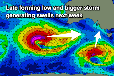 As touched on briefly in Wednesday's notes, there's another significant low forecast to develop south-west of WA through early next week, though comparing it to this week's bombing system, it will be located a touch further north and west initially, but move more into our swell window through next week.
Size wise we're probably looking at a peak similar to that seen yesterday afternoon (likely a bit better on the Mid Coast), and with favourable winds for the Mid Coast.
Ahead of this a small low forming late in our swell window Sunday should produce a fun pulse of SW groundswell for Wednesday as winds swing back offshore from the N/NE. Size wise it's a good one for the South Coast with sets to 2-3ft off Middleton with a morning N/NE breeze.
Check back Monday for an update on Wednesday and Friday's swell and in the meantime, have a great weekend!