Small ahead of a large, windy swell

South Australian Forecast by Craig Brokensha (issued Monday 4th November)
Best Days: South Coast tomorrow, Mid Coast early, South Coast Thursday, Mid Coast Sunday morning
Recap
A good increase in W/SW swell for the Mid Saturday to 2ft but bumpy with a moderate onshore wind, a bit bigger yesterday but messier with fresher winds.
The South Coast was on the small side with the westerly swell direction but clean each morning.
Today the swell was up and hanging around 2-3ft on the Mid Coast, but still average with onshore winds, clean early on the South Coast, but only small again.
This week and weekend (Nov 5 - 10)
Our current mid-period W/SW swell will start to ease through tomorrow, dropping from a small 2ft off Middleton, with easing 1-2ft waves on the Mid Coast.
The South Coast is the pick with a W/NW tending NW breeze, back to the W/NW later afternoon, so hit the exposed beaches for the best of it. The Mid may see a more variable breeze at dawn and cleaner conditions.
 A low point in swell is due Wednesday morning with an early W/NW breeze ahead of a shallow W/SW change which is expected to shift back to the W/NW through the afternoon and strengthen.
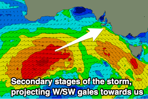
This will be associated with a strong mid-latitude front pushing in from the west, with a late increase in W/SW windswell likely across both coasts through the mid-late afternoon, ahead of a larger groundswell Thursday.
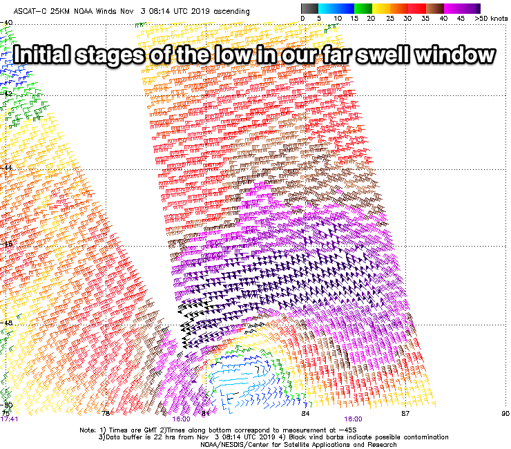
This was talked about last Friday but there's been an upgrade in size. Over the weekend, a tight and intense low formed around the Heard Island region, generating a tight fetch of severe-gale to storm-force W'ly winds in our far swell window.
The low is forecast to move slowly east and then east-northeast up towards the Bight over the coming days and then onwards to us Wednesday.
 A fetch of gale-force W/SW winds will continue to be projected towards us, stronger than forecast on Friday with the front clipping us Wednesday afternoon.
We'll see a mix of W/SW groundswells filling in on Thursday, peaking into the mid-late afternoon with the Mid Coast due to build to an easy 3ft (likely bigger bombs), with the South Coast kicking to 5-6ft off Middleton.
Winds will be strong and out of the W/NW all day, favouring protected spots down South, with Friday looking a stormy mess on the Mid with strong W/SW tending SW winds, poor down South as well. Easing 3ft+ waves are due Friday on the Mid, smaller Saturday but with lingering SW winds.
More favourable and variable winds are due on Sunday as the swell continues to ease, while persistent weak fronts moving through our swell window will keep fun levels of mid-period swell hitting the coast. More on this Wednesday.