Easing surf with improving conditions to end the week

South Australian Forecast by Craig Brokensha (issued Wednesday 21st September)
Best Days: Thursday mid-morning onwards South Coast, Thursday morning Mid Coast, Friday South Coast, Sunday both coasts, Monday morning South Coast
Recap
Great waves yesterday across the South Coast with offshore winds and a good sized swell before sea breezes kicked in. A stronger onshore change moved in overnight. The Mid Coast was tiny, increasing a touch into the afternoon.
Today a new W/SW groundswell is providing 2ft sets on the Mid Coast (under the expected 2-3ft) but with freshening onshore winds, while the South Coast was a total mess with strong onshore winds.
This week and weekend (Sep 22 - 25)
Today's kick in W/SW groundswell will ease back into tomorrow and conditions will remain average down South with a S/SW wind at dawn, but this expected to tend more variable through the day, creating improving conditions. Middleton should ease back from 3ft. The Mid Coast should see fun easing 1-2ft sets with a light offshore wind.
Friday will be much better on the South Coast with offshore N/NE winds, tending variable into the afternoon. Small 2ft waves are due at Middleton, with 3-4ft sets at Waits and Parsons.
Saturday isn't looking too flash with a further drop in swell under a gusty N'ly wind ahead of a SW change.
Our new pulse of groundswell linked to this change is still on track, with it changing a little since Monday.
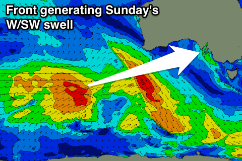 The direction is expected to be more W/SW with the swell already being partly generated by a strong mid-latitude front moving through the south-east Indian Ocean. This front will weaken while pushing towards and through the Bight Friday and Saturday morning, generating a good W/SW groundswell for Sunday.
The Mid Coast should see 2ft+ sets, with the South Coast coming in around 3ft+ off Middleton. NW winds will favour the South Coast, but the Mid should be OK.
The swell is due to ease back into Monday with NW winds ahead of another SW change, with fun pulses of swell due later Tuesday and Wednesday ahead of a possible stronger swell late week. The models are divergent regarding this though, so have a check back Friday for the next update.