Fun waves on the Mid Sunday, improving down South through the week

South Australian Forecast (issued Friday 22nd July)
Best Days: Sunday morning down South, all day on the Mid, Monday on the Mid, Tuesday down South, Wednesday down South (Mid in the arvo), Thursday both coasts
Recap
The Mid continued to offer inconsistent 1ft sets yesterday before backing off today, but the South Coast saw a good new swell fill in to 3-4ft across Middleton with bigger sets at exposed breaks under light to moderate N/NE winds. Conditions became a little bumpy into the afternoon with an E'ly, but it didn't do too much damage.
Today the swell is on a steady drop but conditions are great down South for exposed spots with a freshening N/NE breeze. Make the most of it as the swell will be small to tiny come tomorrow.
This weekend (Aug 23-24)
Saturday is still looking like a good rest day as the swell becomes small to tiny down South under strong offshore N'ly winds ahead of a W'ly change probably around early afternoon.
The Mid Coast will see a late increase in size to 1-2ft as the forerunners of the strong W/SW groundswell due Sunday fills in but conditions will be poor with the onshore W/SW winds.
There's been no real change to Sunday's powerful long-range W/SW groundswell, generated by a monster frontal progression in the Southern Indian Ocean.
This swell is building strongly across WA today and should reach a peak this evening, with it travelling towards us tomorrow, arriving very late and peaking Sunday morning.
The Mid Coast should offer inconsistent but strong 2-3ft sets while the South Coast should see 3-5ft sets at Middleton with larger 6ft+ bombs at more exposed breaks.
Winds are a little tricky and will vary during the day with a weakening trough moving east under us likely resulting in early W'ly tending S/SW winds across the South Coast, while the Mid should see variable winds through the morning, coming up from the S'th a touch and then tending S/SE near dark.
Next Monday onwards (Aug 25th onwards)
Sunday's strong W/SW groundswell will back away through Monday and further Tuesday and Wednesday, but a reinforcing W/SW swell for Monday afternoon should slow this trend across both coasts.
Winds will be favourable for the Mid Monday and offshore from the E/SE with 2ft or so of swell but the South Coast will remain average with an E/SE tending S/SE breeze.
Tuesday will be better down South with a morning NE'ly, while Wednesday should be even straighter with N/NE tending variable winds, but the swell will be small during the morning.
Into Wednesday afternoon though a new strong long-range and inconsistent W/SW groundswell is due, very similar to Sunday's swell.
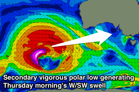 The system generating this swell will be a touch further south and better positioned for us, and while shorter-lived winds should reach the stronger storm-force range through Sunday.
The swell should arrive Wednesday afternoon, building to 2ft across the Mid late in the day before peaking Thursday morning to an inconsistent 2ft to occasionally 3ft. The South Coast should again see 3-5ft sets at Middleton with 6ft bombs at Waits under N/NE tending variable winds.
This will create excellent conditions across both coasts, well worth pencilling into the diary.
Friday will be great down South as the swell eases under offshore N/NW winds, but we'll look at this again Monday. Have a great weekend!