Easing surf with S/SE winds, large swell for Tuesday

Nias, Mentawai, South Sumatra forecast by Craig Brokensha (issued Thursday 3rd September)
Best Days: Protected spots tomorrow and then from Monday afternoon onwards
This week and next week (Sep 4 - 11)
The large and strong S/SW groundswell seen at the start of the week has been easing the last couple of days and will continue to drop away through tomorrow from 3-5ft across exposed breaks, smaller into Saturday. Unfortunately our persistent and average S/SE winds are due to remain steadfast through the coming period, weakening a touch Monday afternoon but the freshening again into Tuesday.
A small kick in background S/SW groundswell is due Sunday to an infrequent 3-5ft across exposed breaks again ahead of a much larger and stronger S/SW groundswell Monday afternoon, peaking Tuesday.
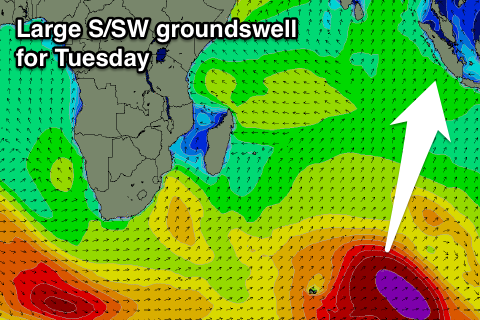 This has and is still being generated by a very strong polar frontal progression firing up west of Heard Island, pushing east-northeast while generating a fetch of severe-gale to storm-force W/SW winds. Satellite observations have picked up the initial fetch of storm-force winds nicely as well.
This swell should fill in strongly Monday afternoon and reach 6-8ft across exposed breaks by dark, peaking Tuesday in the 8ft+ range. A drop is then due through Wednesday further into the end of the week.
Longer term a moderate to large sized S/SW groundswell is on the cards for Saturday week, but with persistent S/SE winds. We'll review this again Tuesday though.
16 day Mentawai forecast graph
16 day Nias forecast graph
16 day South Sumatra forecast graph