Indonesia/Maldives forecast May 23

Indian Ocean Basin analysis by Craig Brokensha (issued Thursday 23rd May)
This week through next (May 24 - 31)
After bottoming out today, a small, inconsistent background SW groundswell is due tomorrow building through the afternoon, peaking through Saturday.
Into Sunday a better pulse of reinforcing SW swell should arrive, generated by a brief but intense low that formed north-east of the Heard Island. This has been upgraded a little with the swell due to reach 5-6ft on the sets when it peaks through the day, easing a touch through Monday.
We then look at the various pulses of SW groundswell due from Tuesday through next week, and overall the progression is healthy and looks to be still on track from the expectations in Tuesday's outlook.
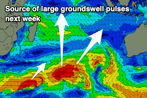
An initial strong system moving through the Indian Ocean has generated a great fetch of weakening, gale to severe-gale W/SW winds and this should produce Tuesday’s pulse of energy, building to a peak through the afternoon, easing into Wednesday.
Secondary activity with less strength more in our southern swell window should produce reinforcing pulses of still large but smaller S/SW energy later week, fading through the weekend.
Longer term, it looks like we could see a larger swell producer firing up through the Indian Ocean later next week, producing a large swell for early the following week. More on this Tuesday.
Over in the Mentawais, funky levels of mid-period W/NW swell are due all peirod, biggest across northern regions thanks to persistent, strong monsoonal W/SW-SW winds off Sri Lanka. These winds might migrate east and interfere with the northern regions later next week but we'll keep an eye on it.
----------------------------------------------
Looking at the Maldives and we’ve got a mix of easing S’ly groundswell and new moderate sized, mid-period S’ly swell on the build.
This mid-period energy should hold tomorrow and Saturday morning before easing a touch into the afternoon and Sunday.
We’ll then see building levels of SE trade-swell through mid-late next week, easing thereafter as a surge of SE trades develop through the northern Indian Ocean.
Of greater significance are the S’ly groundswell pulses from the activity across the southern Indian Ocean.
The first and largest should arrive through Sunday but peak Monday, easing slowly through the rest of the week.
We’ll likely see further pulses of strong S’ly groundswell late next week and the following weekend from significant storms firing up under South Africa, but check back here on Tuesday for the latest.
Eastern Indonesia:
Inconsistent SW groundswell building later tomorrow, peaking Saturday to 4ft+ across the magnets.
Secondary S/SW groundswell building Sunday, reaching 5-6ft into the afternoon, easing Monday.
Large SW groundswell building Tuesday, reaching 8ft+ into the afternoon, easing slowly Wednesday from a similar size.
Reinforcing S/SW groundswell to 6ft+ Friday afternoon, easing Saturday.
Possible larger swell the following week,
Moderate to fresh E/SE trades (weaker over the coming days and stronger Sunday/Monday), variable offshore each morning. Weaker trades most of next week.
Uluwatu 16-day Forecast Graph/WAMs
Western Indonesia/Mentawais/South Sumatra:
Moderate sized S/SW groundswell for tomorrow to 4-5ft on the magnets, holding Saturday.
Reinforcing S/SW groundswell Sunday to 4-6ft.
Large S/SW groundswell building later Monday, reaching 8ft+ into Tuesday, easing slowly Wednesday.
Reinforcing S/SW groundswell to 5-6ft Friday to.
Persistent, small-moderate sized mid-period W/NW swell across northern locations.
Variable winds, tending S/SE from tomorrow across southern locations and strengthening across all spots into Saturday, variable to the north again from Sunday.
Weakening winds to the south through early next week.
Possible W-SW winds later week in northern locations.
Mentawai 16-day Forecast Graph/WAMs
Maldives:
New moderate + sized mid-period S’ly swell today to 4-5ft+ across the southern atolls, easing to 4ft tomorrow.
Small-moderate sized SE trade-swell building slowly Sunday, stronger mid-late week to 4-5ft across most locations.
Moderate to large S’ly groundswell building later Sunday, peaking Monday, reaching 4-6ft into the afternoon across the southern atolls, easing Tuesday.
Weak W’ly windswell in the mix across selected locations this week.
Strong W/SW winds (SW across southern locations) tomorrow, easing very slightly into the weekend but persisting next week from the W/SW (fresh northern locations, moderate southern locations).
Winds possibly strengthening from the W mid-late week.
Comments
Latest notes are live.
Swell for weeks, thanks
what's the likely hood of any of that strong sly swell arriving next weekend in Maldives wrapping around to SE facing spots (Male Atolls). Will the long period wrap and compensate for the less than ideal direction
thanks
Yep they do get in but with less size.
In my experience the Nth Male Atolls do not pick up any swell west of south. I know the fetch/storm/swell you're referring too for next weekend and if it does come off the swell periods in the Maldives will be rather long. I have men on the ground in the Maldives for the next two weeks+ so will definitely know if this storm/swell makes it into the North Male atolls next weekend or not.
My gut feel is the lower of the two periods currently forecast to arrive Nth male on Friday 31st May won't get into the Nth Male Atolls, but my gut feel for the second, stronger pulse for late Sat 1st June/Sunday 2nd June could potentially wrap up into the Nth male atolls. For reference, I'm basing it off current forecasts as follows:
Friday 31st May - 0.5-0.7m@18-19 sec
Sat 1st June (late) - 0.7-0.8m@25-26 sec
Sun 2nd June - 1.1-1.3m@21-23 sec
Bigger issue is local winds which are right shyte ATM
I also note considerable divergence between EC and GFS on this storm/fetch intensity and location so I'm expecting some rather large movements in the forecast numbers early-mid next week still. I am actually prefering/liking the position of that EC fetch SW of Heard Island For Thurs 30th.....that's a much much better aligned fetch/swell window for the Nth Male Atolls compared to GFS's position.
First round of SW/S swell didn’t make it up to the Nth Male Atolls. But that second longer period and more due south swell has. Started filling in late Sat, more so yesterday and is a good 4ft sets this morning up there.
Yeah first was from a source more tucked under South Africa.
How's the EC forecast in the Southern Ocean for the first weekend of June!!!
Anyone been watching the Krui comp today? Got too big to run in the end. Only one jetski to get guys out the back. Looked triple overhead on Billy
Was it at the point out of town? I had a look briefly last week and they were running it at the left in town. Was small but looked very fun.
https://www.theguardian.com/world/article/2024/jun/03/maldives-israel-pa...
So that makes indo & maldives