Indonesia/Maldives forecast Jul 31

Indian Ocean Basin analysis by Craig Brokensha (issued Thursday 31st July)
This week through next (Aug 1 - 8)
Large surf seen through yesterday should be on the ease, with the trend continuing through tomorrow. Some small background S/SW groundswell pulses are still on the cards for Saturday/Sunday but no major size is due from these sources.
We then look towards our active week of swell into next week.
There’s no change to the start of the week, with an initial large SW groundswell expected to move in Monday, generated by a strong mid-latitude low that pushed north above the Heard Island region.
This low has since generated an additional fetch of S/SW gales between Heard Island region and Western Australia with a large reinforcing S/SW groundswell due Tuesday morning.
Of greater significance is a stronger polar low projecting from the Heard Island region up towards Western Australia from tomorrow through the weekend. A fetch of storm-force W/SW tending SW winds should ease back to severe-gale through Saturday evening, with an oversized, long-period S/SW groundswell due into Wednesday.
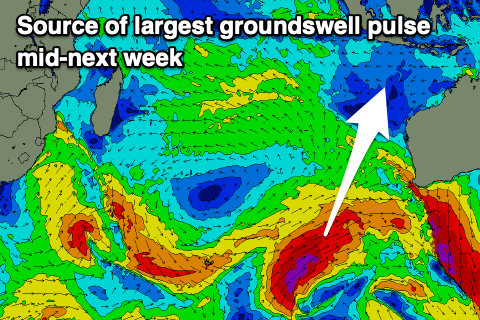
The size looks to be the biggest we’ve seen this season, with a peak due through the morning, easing into the afternoon and further Thursday.
A slightly smaller reinforcing S/SW groundswell may be seen into later week, but we’ll look at this closer on Tuesday.
The current, strong SE trades are expected to ease tomorrow and tend more E/SE-SE on the weekend, freshening a little through next week from the E/SE. Light, local offshore winds are due each morning.
In the Mentawais, the first swell for Sunday is still looking large with the secondary pulses coming in more S’th. A secondary pulse is due Monday, while the largest is also due Wednesday, peaking into the afternoon.
A S/SE trade-swell also in the mix is due to fade through this week with variable winds due to freshen from the N/NW-NW later tomorrow but more so over the weekend, persisting early next week, possibly weakening from Wednesday.
----------------------------------------------
Maldives:
The trade-swell has backed off a little from the large pulse seen earlier this week, though we’re still seeing moderate + levels of energy, with a moderate + sized S/SW groundswell due to be in the mix tomorrow.
Saturday should see a slow easing trend from both directions, smaller Sunday morning ahead of a new pulse of moderate + sized S/SW groundswell into the afternoon, generated by the secondary intensification of the mid-latitude low generating tomorrow’s pulse of groundswell.
The strong polar frontal progression surge towards Western Australia isn’t expected to generate any major size mid-next week, with localised S/SE trade-swell expected to come in more dominant. This looks to be generated by a fresh fetch of SE trades setting up south of us on the weekend, shifting more east into early next week. A small tropical low forming in the trade-flow may generate the most size mid-week, moderate + in size, but we’ll review this Tuesday.
Local winds are strong from the NW but expected to ease into the weekend, shifting W/NW early next week before strengthening again from Tuesday.
Eastern Indonesia:
Small to moderate sized, inconsistent S/SW groundswell Saturday/Sunday.
Large SW groundswell for later Sunday, peaking Monday morning to 6-8ft with a secondary slightly bigger S/SW groundswell for Tuesday morning to 8ft across exposed breaks.
Oversized, long-period S/SW groundswell Wednesday, peaking to 10-12ft across exposed breaks, easing Thursday.
Easing SE trades tomorrow, tending more E/SE-SE on the weekend, then freshening a little through next week from the E/SE. Light, local offshore winds are due each morning.
Uluwatu 16-day Forecast Graph/WAMs
Western Indonesia/Mentawais/South Sumatra:
Large SW groundswell for Sunday afternoon to 6-8ft, holding Monday morning.
Secondary pulse of S’ly groundswell likely Tuesday to 6-8ft.
Larger S’ly groundswell for Wednesday afternoon to 10ft.
Variable winds today, freshening from the N/NW-NW later tomorrow but more so over the weekend, persisting early next week, possibly weakening from Wednesday.
Mentawai 16-day Forecast Graph/WAMs
Maldives:
Mix of moderate + sized SE trade-swell and S/SW groundswell to 4-5ft+ (smaller Male), easing slowly Saturday.
Moderate + sized S/SW groundswell building Sunday, peaking to 4-5ft into the afternoon, easing Monday.
Moderate + sized S/SE trade-swell building Tuesday to the 5ft range across the southern atolls, persisting most of the week.
Local, strong NW winds are expected to ease into the weekend, shifting W/NW early next week before strengthening again from Tuesday.
Comments
Latest notes are live.
Great forecast Craigos, that’s what we all wanted to see!
Easy 6ft sets at Kandooma today. Definitely more SE swell direction compared to yesterday
Booyah!!!
with some strong NW wind to boot Don
Yeah I heard winds aren't ideal. Tricky conditions when those strong winds kick in. Big ribs up the face.
Indeed Don, been out of the water for the last 3 days as well due to 6 stitches in foot, leaving for Male in an 1hr. Oh well such is life
Bugger. Reef cut?
Do you wear booties?
Fin and no, not normally but booties would have definitely helped, oh well
Nice.
Yooo craigos
Reckon they’ll run the Padang Cup next Wedneday, or not quite big enough and too south?
Not sure if they have done the trials yet.
Both of those and also a big morning tide as the swell peaks. A good day for the trials though.