Good swells for all regions this weekend

Hawaii North Shore, Micronesia and PNG forecast by Craig Brokensha (issued on Thursday 4th January)
Best Days: North Shore Thursday, then Saturday afternoon through Monday, Wednesday onwards - Micronesia Friday through Tuesday - PNG every day
This week and next (Jan 4 - 12)
Hawaii: Our building and strengthening W/NW groundswell event seen through early this week is peaking today with solid sets across magnets on the North Shore.
We'll see this swell slowly tail away from this afternoon, down from 4-5ft tomorrow morning, smaller Friday.
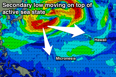 We then look ahead to some good W/NW groundswell that's due to fill in this weekend. We spoke about this swell last update, but since we've had a slight upgrade in the strength of the dual lows spinning off Japan in our western swell window.
An initial low has generated a tight fetch of severe-gale to storm-force W/NW winds, setting up an active sea state for a secondary broader low to move over, projecting slightly weaker gale to severe-gale W/NW winds closer towards us over the coming days.
We should see a large long-period W/NW groundswell arriving overnight Friday, building strongly Saturday and peaking overnight, holding size Sunday morning.
An increase to 8ft on the sets is due by dark Saturday, with similar 6-8ft surf Sunday morning, easing slowly through the day, down further from the 6ft range Monday morning.
Winds will be great through this period with fresh and gusty E/NE trades, relaxing on the backside of the swell Monday and Tuesday.
Longer term there are a couple of significant developments on the cards, but more on this Tuesday.
North Shore Forecast Graph
North Shore WAMs
Micronesia: The good swell seen over the weekend has eased, but we're still seeing fun sized sets hanging in across reef passes exposed to the north.
 A new reinforcing pulse is due to build this afternoon and peak tomorrow to 3-4ft+, but we've got some better developments on the cards for the weekend.
The vigorous storms forming off Japan mentioned above in the Hawaii section have generated a large N/NW groundswell for us this weekend. We should see it build through Saturday to a strong 6-8ft by evening across the region, peaking overnight and dropping from a similar size Sunday morning.
E/NE trades will create good conditions, strengthening through next week as the swell continues to fade while also bringing an increase in E/NE trade-swell later week.
Longer term the more significant developments in the Pacific Ocean for Hawaii will form too late and east in our swell window, but more on this Tuesday.
Palikir Pass Forecast Graph
Palikir Pass WAMs
Papua New Guinea: As with Micronesia, the swell seen earlier in the week has eased, but our rare N/NE groundswell generated off the Kamchatka Peninsula over the weekend is still on the cards.
This swell will be very inconsistent and arrive through today, building to 3ft on the sets, holding Friday and Saturday.
We then look at the larger N/NW groundswell due from the lows off Japan, and we should see an increase through Sunday, with magnets reaching an inconsistent 4-5ft, peaking overnight and easing from a similar size Monday.
Weak E'ly trades are expected through this period, more variable each morning creating good conditions.
Longer term we're looking at small amounts of NE trade-swell but more on this Tuesday.