Good NW swell for Saturday, more activity next week

Hawaii North Shore forecast by Craig Brokensha (issued Wed 7th December)
Best Days: Thursday morning, Saturday for experienced surfers, Sunday morning, Tuesday morning for experienced surfers
 This week and weekend (Jan 8 - 11)
A strong pulse of N'ly groundswell (with a touch of west in it) due to fill in today was generated by an elongated fetch of N/NW gales extending down from the Aleutians. This swell should come in at 8ft+ across exposed breaks on the North Shore today before starting to ease towards the evening and drop back from the 6ft+ range tomorrow morning, easing further into Friday.
Poor N/NE winds this morning should swing more towards the E/NE this evening with favourable E'ly offshores tomorrow and Friday morning with sea breezes likely into the afternoon.
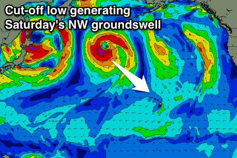
Into the weekend we should see a moderate and more ideal pulse of NW groundswell Saturday from a healthy cut-off low currently positioned to our north-west.
A fetch of severe-gale to storm-force NW winds have been aimed towards Hawaii yesterday and into the evening, with the low now weakening while projecting slightly towards us today and tomorrow.
The swell should peak Saturday morning to 6-8ft with the rare bigger set across swell magnets on the North Shore before easing back into the afternoon and further down from 4-5ft+ Sunday morning.
Winds should remain good and offshore each morning over the weekend before afternoon sea breezes kick in.
 Next Monday onwards (Jan 12 onwards)
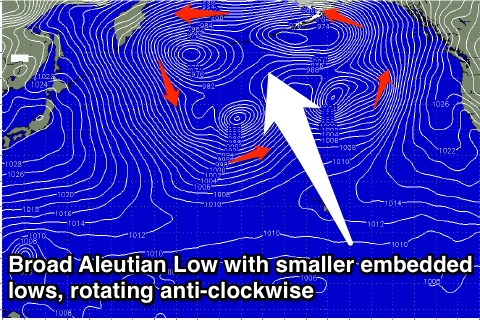
From Monday we'll enter an active period of swell as broad Aleutian Low develops to our north-west, with a series of vigorous storms cycling anti-clockwise around it, producing moderate to large pulses of groundswell.
An Aleutian Low is a semi-stationary and very broad low pressure centre that sits around the Aleutian Islands, with smaller embedded lows and storms cycling around it.
This is what will take place through next week, with an initial strong but small storm producing a moderate-large NW groundswell for later Monday and more so Tuesday morning in the 10ft range.
A couple of secondary stronger and broader fronts will move through Hawaii's western swell window, closer to the islands, producing larger levels of W/NW groundswell for the end of the week that looks at this stage to come in around the 12-15ft range.
The only issue with these swells is that the close nature of each storm will bring with it poor Kona winds from the S/SW during most of next week. There's a chance winds will become more variable into Friday and tend back to the E/NE next weekend, but we'll review this and the size estimates again on Tuesday.
Comments
Frothing!!