Smaller, flukey swells

Eastern Tasmania Surf Forecast by Craig Brokensha (issued Wednesday 24th February)
Best Days: Keen surfers tomorrow morning and Friday morning
Features of the Forecast (tl;dr)
- Easing E/NE swell tomorrow with strengthening N/NW tending NW winds ahead of a late S/SW change
- Mix of small NE swell and building S swell Fri with W/SW tending strong S/SE winds, easing Sat with SW tending SE winds
- S'ly swell pulse Tue AM with fresh S/SW tending S/SE winds
Recap
Good though inconsistent waves out of the east-northeast yesterday and today with favourable winds each morning. Make the most of it as we'll see the swell tail off considerably through tomorrow.
This week and weekend (Feb 25 - 28)
The low moving south through the Tasman Sea, bringing yesterday's and today's fun E/NE swell has since cleared our swell window and we'll see the size dropping back from a slow 2ft to possibly 3ft at dawn tomorrow, tiny into the afternoon.
Conditions will be nice and clean with a freshening N/NW tending NW breeze ahead of an evening S/SW change.
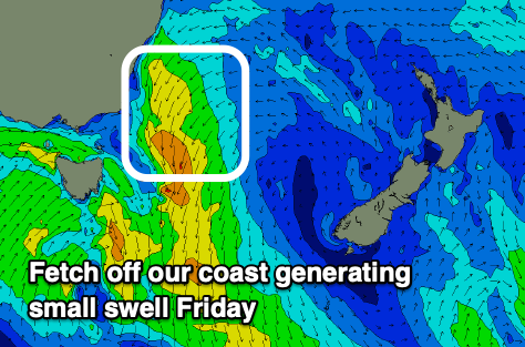 Friday should still see small levels of NE swell as a fetch of strong NE winds develop at distance to our coast tomorrow, providing inconsistent 2ft sets across the swell magnets.
A surface trough forming into a weak low will also generate the weak S'ly swell for the afternoon with 2-3ft waves due across the south magnets but with W/SW tending strong S/SE winds.
Saturday morning should see winds tend back to the SW temporarily but the swell will be on the way out, easing from 2ft+ or so.
Longer term, as touched on last update there's nothing significant on the cards with another trough due to bring a strong S'ly change late Monday and spike in S'ly swell Tuesday. This trough looks stronger than Friday's with a bit more size to 3ft+ or so likely but with S/SW tending SE winds.
Behind this there's nothing of note, so maybe try the South Arm Forecaster Notes for more options.