Inconsistent cyclone swell followed by a spike from the south

Eastern Tasmania Surf Forecast by Craig Brokensha (issued Wednesday 1st January)
Best Days: Tomorrow and Friday morning, late Saturday southern corners, Sunday afternoon northern corners, Monday morning
Recap
Happy New Year! Good waves in protected southern corners yesterday with a new NE swell and S/SE winds, average to poor across other breaks.
This morning conditions were clean across most spots with the swell continuing at 2ft to occasionally 3ft.
This week and weekend (Jan 2 - 5)
With the N/NE windswell fading through today we look to the inconsistent and flukey NE groundswell from Tropical Cyclone Sarai.
Sarai has moved out of our swell window, with the swell on the way to us through the Tasman Sea.
 We should see varying pulses through tomorrow and Friday, ebbing and pulsing around 2ft to possibly 3ft across north-east swell magnets, easing off into Saturday. There'll be long waits between sets to be patient.
Winds tomorrow will be offshore in the morning ahead of E/NE sea breezes, similar Friday.
As the cyclone swell fades, some fun new N/NE windswell is on the cards for Saturday with an elongated fetch of strong N/NE winds forming in our swell window Saturday morning.
The swell from this system looks a bit smaller than expected on Monday with a kick to 2-3ft due through the day Saturday with N/NW tending N/NE winds ahead of a late gusty S'ly change. Hit the north-east magnets late!
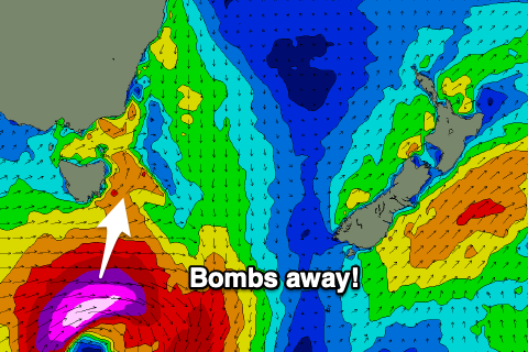
We then move onto the 'bombing low' and the swell from this system has been upgraded slightly.
A 'bombing low' is a storm that drops 24hPa or more in central pressure in a period of 24 hours, and this will happen through Saturday.
We're now expected to see the low form earlier, projecting a fetch of severe-gale to storm-force W/SW-SW winds through our swell window Saturday, moving off quickly to the east on Sunday.
A solid spike in S'ly groundswell is expected from the low, peaking through Sunday to 3-5ft across south swell magnets, but fading just as quickly Monday from 2ft.
Winds will swing from S/SW to NE, favouring south swell magnets into the afternoon and evening, W/SW to E/NE on Monday.
Longer term we're looking at some small N/NE windswell, but more on this Friday and an update on the weekend's swell.