Tiny waves and poor outlook ahead

Eastern Tasmania Forecast by Craig Brokensha (issued Wednesday 24th December)
Best Days: No good days
Recap
Some good NE windswell developed through yesterday as early light winds swung offshore ahead of a late S'ly change. This provided good waves across spots exposed to the swell into the evening.
With the change the swell has eased back to a smaller 1-2ft today with less than ideal winds.
 This week and weekend (Dec 25 - 28)
With the NE swell backing off through today there's nothing significant at all on the cards for this week with only remnant levels of NE swell due through tomorrow and Friday. This will only provide 1ft sets before fading into the weekend.
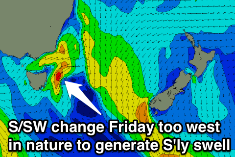
A S'ly change on Friday will be too short-lived and south-southwest in nature to generate any S'ly swell with tiny waves out of the E/NE due to persist into Saturday and also Sunday to 1ft+ or so.
Monday onwards (Dec 29 onwards)
Besides a small increase in NE windswell Monday to 1-2ft or so across north-east facing beaches, there's nothing major at all on the cards unfortunately.
Refracted S'ly swell showing on the charts for later in the week will be too west in nature to really impact us with only 2ft sets max due at south swell magnets if anything. We'll provide an update on this on Friday though.