Southerly swells from Thursday

Eastern Tasmania Forecast by Craig Brokensha (issued Monday 24th November)
Best Days: Friday morning, Saturday morning, Sunday morning
Recap
Nothing of real note across the coast over the weekend with tiny conditions for the most part.
This week and weekend (Nov 25 - 30)
The coming days will remain near flat as a series of relatively weak frontal systems pushing across us have a too zonal projection, with the swell being too west in nature.
Into Wednesday and Thursday though, a better aligned polar front pushing up past us should generate a fun S'ly groundswell pulse for late in the day Thursday and more so Friday morning.
This swell should come in at a small 2ft across south swell magnets, with tiny surf at remaining open beaches. Conditions are looking favourable with a morning W/NW wind ahead of afternoon sea breezes.
 The swell should ease through Friday afternoon and further Saturday, but a small reinforcing S/SE swell is due to keep 2ft sets hitting south facing locations, generated at the base of the parent low at the core of the fronts pushing through tomorrow and Wednesday.
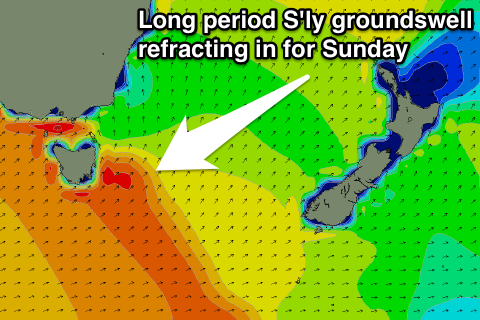
Into Sunday a new larger period S'ly groundswell should refract into the coast. This will be produced by a strong polar low firing up along the polar shelf and then projecting north-east towards New Zealand through the end of the week.
The swell from this system should reach 2ft+ across most south facing breaks Sunday with the odd bigger bomb possible at south swell magnets. NW to NE winds should favour these spots, while the swell will fade to nothing Monday.
Longer term there's nothing major on the cards besides small levels of NE windswell but we'll look at this again Wednesday.