Lots of swell, climaxing and dangerous Monday morning

Java, Bali, Lombok, Sumbawa forecast by Craig Brokensha (issued Thu 11th Sep)
Best Days: Every day over the coming period for experienced surfers
Tomorrow and this weekend (Sep 12 - 14)
A strong S/SW groundswell showed later yesterday and has peaked this morning with solid waves across all breaks, maxing out at exposed locations.
This swell should drop back through this afternoon and further tomorrow, with exposed spots in Bali due to still offer 10ft sets before easing back to the 8ft range into the afternoon.
A reinforcing and more acute S/SW groundswell is due on Saturday and this should provide very inconsistent 8-10ft sets at exposed spots in Bali again, with less size than the current swell east towards Sumbawa. A drop in size is then due through Sunday ahead of a late kick in strong and powerful SW groundswell, discussed below.

Moderate to fresh E/SE trades are expected over the coming period, lighter and variable each morning in selected regions, with the most strength currently expected Sunday afternoon.
Next Monday onwards (Sep 15 - 24)
We've received some great and frightening satellite passes over the polar storm generating Monday's oversized and dangerous SW groundswell.
A fetch of 50-60kt W/SW winds have been recorded, remaining at strength for nearly 24 hours, with the system now weakening as it pushes towards WA.

A large, long-period SW groundswell is now spreading up towards us and should show later Sunday (with 25s fore-runners arriving the evening before) building to at least 8ft across exposed breaks by dark before peaking Monday morning to a very large but inconsistent 12ft+ across exposed breaks with the odd 15ft bomb possible.
The extra long period will help the swell refract in at size across most breaks, so it will be only for the most experienced and seasoned surfer.
A slow drop in size should be seen through the day, easing back further from 8ft+ Tuesday morning and further into Wednesday morning. Winds will continue from the E/SE, becoming moderate to fresh into the afternoon.
The next increase in size is due Wednesday afternoon and Thursday morning, with this being another large long-period number, but nowhere near the size of Monday morning's swell.
This will be produced by a secondary polar low firing up further east and being a touch smaller than the system before it, generating a fetch of severe-gale to storm-force W/SW winds through our southern swell window.
A good but inconsistent S/SW groundswell will result, pulsing strongly later Wednesday to 8ft+ across exposed spots in Bali before easing from 6-8ft+ Thursday morning.
From here on into the weekend the swell will drop away as E/SE trades weaken, opening up more exposed locations.
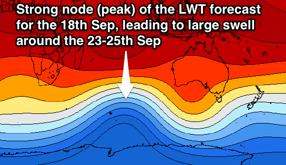 Longer term, another strong amplification of the Long Wave Trough is expected to strengthen through the Southern Indian Ocean around the 17-18th of September, producing a couple of large groundswell pulses for the 23-25th of September. More on this Tuesday though.
16 day Bali Forecast Graph
16 day East Java Forecast Graph
16 day Sumbawa Forecast Graph
Comments
is this the same swell that is meant to be hitting tahiti ?
no, but you have just won 'post of the year'
No Luca, here's the storm that generated the Indo swell in the Indian Ocean (south-east of South Africa).
And here's the storm that generated the Teahupoo swell in the South Pacific Ocean.