The coming period isn't great at all with smaller swells and average winds.
Primary tabs
/reports/forecaster-notes/western-australia/2025/08/06/make-the-most-today-and-tomorrow
Craig
Wednesday, 6 August 2025
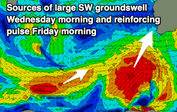
/reports/forecaster-notes/western-australia/2025/08/04/great-surf-developing-the-week-unfolds
Craig
Monday, 4 August 2025
We've got improving conditions and more large surf on the way with the waves expected to become great from Wednesday.
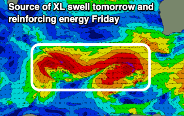
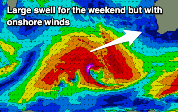
/reports/forecaster-notes/western-australia/2025/08/01/xl-stormy-weekend-great-mid-late-next-week
Craig
Friday, 1 August 2025
The weekend is a write-off with improving surf across metro locations early week, better across the South West from Wednesday onwards.
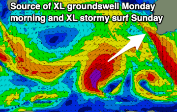
/reports/forecaster-notes/western-australia/2025/07/30/cleanest-today-and-early-tomorrow
Craig
Wednesday, 30 July 2025
Make the most of the favourable winds before oversized, stormy surf kicks in from the weekend.
/reports/forecaster-notes/western-australia/2025/07/28/easing-improving-surf
Craig
Monday, 28 July 2025
The current large swell will ease steadily into tomorrow as winds slowly improve, best Wednesday morning but smallest. A new SW swell will arrive through the day though.
/reports/forecaster-notes/western-australia/2025/07/25/mostly-average-weekend-large-and-windy-early
Craig
Friday, 25 July 2025
Besides early tomorrow the weekend looks average with deteriorating winds. Large surf is due early next week but with strong winds.
/reports/forecaster-notes/western-australia/2025/07/23/easing-surf-winds-improve
Craig
Wednesday, 23 July 2025
Metro regions will fair best again with the South West taking its time to clean up as the swell fades.
/reports/forecaster-notes/western-australia/2025/07/21/windows-opening-later-week
Craig
Monday, 21 July 2025
The run of onshore conditions for the South West should ease temporarily later week, though the swell isn't as big as it appears.
/reports/forecaster-notes/western-australia/2025/07/18/window-light-winds-tomorrow
Craig
Friday, 18 July 2025
Tomorrow is worth capitalising on before the next episode of frontal activity moves in.
/reports/forecaster-notes/western-australia/2025/07/16/larger-surf-come-couple-windows-the-north
Craig
Wednesday, 16 July 2025
Metro locations will be the pick this period with persistent onshore breezes to the south.