Easing surf as winds improve

Western Australian Forecast by Craig Brokensha (issued Wednesday July 23rd)
Best Days: Protected spots tomorrow, Friday morning all locations, Saturday morning in the South West, Tuesday morning all locations, Wednesday morning in the South West
Features of the Forecast (tl;dr)
- Large mix of swells tomorrow with strong S/SE tending S winds
- Easing surf Fri with light-mod S/SE-SE tending S/SW winds in the South West, E to the north in the AM ahead of weak sea breezes
- Smaller Sat AM ahead of a moderate + sized SW groundswell into the PM, holding Sun
- Dawn E/NE tending N/NE then N/NW winds Sat, strong S/SW Sun (N/NE early to the north)
- Large, weak mid-period SW swell Mon with strong S/SE-S winds
- Easing swell Tue with moderate S/SE tending S/SW winds
- Cleaner Wed but small
Recap
Perth and Mandurah offered light winds and fun, peaky waves yesterday morning with the South West coming in poor and onshore. Today conditions are deteriorating across all locations with a low point in swell and strong cold front pushing up and across the region.
This week and next (Jul 24 - Aug 1)
Today’s onshore change is thanks to a strong, broad though weakening polar front pushing up and across the region, with it bringing a large mix of swells periods and sizes through tomorrow.
The models are over-forecasting the size but we should still see large surf in the 10ft range across the South West with 3ft+ waves in Mandurah, 3ft Perth.
The frontal system will clear west through tomorrow allowing winds to shift S/SE but with strength through the morning, favouring protected southern corners.
Friday is still the pick of the coming days as winds continued to improve, swinging light offshore across Perth/Mandurah but lingering out of the S/SE-SE across the South West, though much lighter in strength.
Tomorrow’s mix of swells will begin easing, dropping from 6-8ft in the South West, 2-3ft Mandurah and 2ft+ Perth.
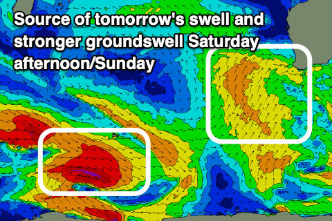
Come Saturday, a low point in swell is expected through the morning, just when winds ease further and shift E/NE through the morning. It’ll be a bit lumpy but worth a surf in the South West early before the next approaching trough brings slowly increasing N/NE tending N/NW winds.
These increasing winds will spoil a new SW groundswell that’s due into the afternoon, with it generated by a strong but short-lived polar low that formed south-east of South Africa earlier this week.
No major size is due (6ft+ Margs) with the swell expected to hold its size into Sunday morning but with strong S/SW winds (possibly N/NE early in the north).
Sunday’s change will be linked to another weak polar front pushing up and across us, with another weak, though sizey increase in localised swell due through Monday along with strong S-S/SE winds.
The size doesn’t look to be that seen tomorrow, with easing surf Tuesday as winds weaken and remain from the S/SE Tuesday, more offshore Wednesday. A repeat of this Thursday/Friday Saturday but with less size and power.
Longer term, more large onshore surf is due from later next week, but more on this Friday.