Easing but improving surf

Western Australian Forecast by Craig Brokensha (issued Monday July 28th)
Best Days: Tomorrow morning all locations, Wednesday in the South West (afternoon to the north), selected spots Thursday
Features of the Forecast (tl;dr)
- Large, easing mid-period S/SW swell tomorrow with mod-fresh S/SE winds ahead of sea breezes
- Smaller Wed AM ahead of a large, new SW groundswell for the PM
- Moderate E/NE tending weak N/NW winds Wed
- Reinforcing, slightly smaller SW groundswell Thu with freshening NE tending N/NE winds (more N/NE in Margs early)
- Easing surf Fri with strengthening N-N/NW winds
- Large, stormy swell building Sat with strong W winds
- XL stormy swell Sun/Mon with strong W/NW winds Sun, W Mon
- Easing swell Tue with SW winds, possibly S/SE early Peth/Mandurah
Recap
All locations offered a fun wave through Saturday morning with plenty of size hanging in at 8ft across the South West, 3ft Mandurah and 2-3ft Perth. Conditions deteriorated through the day as northerly winds strengthened and yesterday was poor in most locations with Perth offering an OK morning of weak waves from the NW.
Today’s we’ve got a large mix of swells with it coming in mostly low in period with peaky options out of the wind in Mandurah and Perth, while Margs is more raw and trickier.

Decent conditions in the South West Saturday morning
This week and weekend (Jul 29 - Aug 3)
The strong frontal system linked to the current large swell has formed a tight low and is stalling off our south coast, with it directing severe-gale S’ly winds up into the region today.
With this, the clearing trend through tomorrow will be stalled, resulting in easing surf but with winds still coming from the S/SE. They’ll ease in strength and be moderate to fresh, with options across all locations. The South West looks to ease from 6-8ft across the exposed breaks with the swell coming in more south, 3ft Mandurah and 2ft to possibly 3ft Perth.
Wednesday will be smaller and weaker with a better E/NE offshore across all spots, giving into weak N/NW sea breezes.
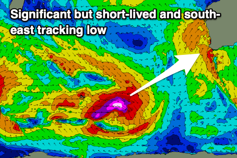
Early looks to start small, but through the later morning, a new long-period SW groundswell is due to arrive, generated by a very strong but short-lived and south-east tracking low that formed around the Heard Island region yesterday. Core wind speeds hit hurricane-force, but the track away from us will limit the expected size.
The South West should still see a strong pulse to 6-8ft through the afternoon with 2ft+ waves in Mandurah, 2ft Perth, easing quickly Thursday. A reinforcing SW groundswell is due Thursday though, generated by a secondary strong frontal system generating severe-gale W/NW winds at right angles to our swell window.
This may maintain 6ft+ waves in the South West, with a drop in swell to the north and winds will still be ok across the metro regions early and NE, N/NE-NE down in the South West, freshening from the N/NE through the day.
Stronger N-N/NW winds will create average conditions through Friday with easing levels of swell, poor and strong W’ly Saturday W/NW into Sunday.

The shift in wind will thanks to a strong frontal progression moving in from the west, with it starting to the south-east of South Africa over the coming days but manifesting in a peak in energy across us through the weekend.
The initial activity is strong but a bit unorganised, generating large swell pulses individually, but a much stronger polar frontal system moving up and into us through Saturday/Sunday from east of the Heard Island region should produce an XL increase in SW swell Sunday/Monday.
Winds will be strong onshore though as the progression pushes high in latitude, with Tuesday offering an improvement in winds across metro regions, but more so Wednesday. We’ll have a closer look at this during the next couple of updates.