Window of light winds tomorrow

Western Australian Forecast by Craig Brokensha (issued Friday July 18th)
Best Days: Tomorrow all locations, Thursday Perth and Mandurah in the morning, Friday morning
Features of the Forecast (tl;dr)
- Large, easing mix of swells tomorrow with variable E/NE tending weak N winds
- Smaller Sun with strengthening N/NW-NW tending SW winds
- Late increase in stormy swell Sun, easing Mon with strong SW winds in the South West, S/SE in the AM to the north
- Smaller Tue with strong W winds in the South West, variable to the north early
- Building large windswell Wed with strengthening W/NW-NW tending SW winds
- Large SW groundswell Thu with strong S/SW winds, weaker S/SE to the north in the AM
- Easing swell Fri with variable E/NE tending N/NW winds
Recap
Our XL groundswell peaked through yesterday with 12-15ft onshore waves in the South West, slightly wind affected 4ft surf across Mandurah and great 3ft+ waves across Perth through the morning under an offshore breeze.
Today all coasts are poor and stormy as the next swell generating front pushes through.
This weekend and next week (Jul 19 - 25)
The weekend and coming forecast period mostly revolves around tomorrow morning’s window of light winds and cleaner conditions, especially across the South West.
We’ve got good model consensus regarding a variable E/NE offshore wind in the South West tomorrow morning, only shifting moderate N’ly into the afternoon.
While not ideal, there should be some quality, improving waves with a bit of rawness to them in the South West, easing back from the 10ft range across exposed breaks while Mandurah should be 3ft or so, 2-3ft in Perth.
Make the most of these lighter winds as stronger N/NW-NW tending SW winds will kick in quickly on Sunday as a strong trough slips in from the west.
This trough looks north-south aligned and not great for swell generation at all, with a weak localised increase in stormy swell due through Sunday evening/Monday along with strong SW winds in the South West, possibly tending S/SE early in Perth/Mandurah. Size wise the metro regions look to be a weak 2-3ft, easing through the day.
There’s a window of possible variable winds on Tuesday morning in metro regions, W’ly to the South but swell wise nothing major is expected as we hit a low point in swell energy.
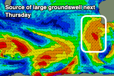
Moving into Wednesday, the next swell generating system will push up and into us, bringing strong W/NW-NW winds ahead of a SW change, with building levels of low period swell due into the afternoon ahead of the larger groundswell Thursday.
A great fetch of gale-force SW winds should produce 12ft+ surf in the South West, 4ft across Mandurah and 3ft+ in Perth Thursday as winds remain strong from the S/SW, Perth and Mandurah should see morning S/SE winds, possibly cleaner Friday across all locations with a light E/NE offshore.
We’ll have a closer look at this Monday, have a great weekend!