Windows opening up later week

Western Australian Forecast by Craig Brokensha (issued Monday July 21st)
Best Days: Tomorrow Perth/Mandurah, protected spots Thursday for the keen, Friday morning, Saturday morning in the South West
Features of the Forecast (tl;dr)
- Easing surf tomorrow with W/SW winds in the South West, variable E/NE to the north
- Smaller Wed AM ahead of a building windswell with strong W/NW tending late SW winds
- Large mix of mid-period SW swell and long-range groundswell with strong S/SE tending S winds
- Easing swell Fri with light SE tending S/SW winds in the South West, E/NE to the north ahead of weak sea breezes
- Smaller Sat with variable winds ahead of sea breezes
- Moderate sized, inconsistent SW groundswell for the PM Sat, peaking Sun AM with strong NW tending SW winds
- Large swell Mon with strong SW winds
Recap
Our window of variable winds expected across the South West unfortunately failed to eventuate on Saturday morning with strengthening onshore breezes and no surf of quality. Perth and Mandurah were much better with great 3ft surf across the former, a little smaller across the latter.
Yesterday was poor across all locations thanks to strengthening N’ly winds ahead of a W’ly change owing to a deep trough moving through.
This has brought a poor quality swell into today across the South West, though Perth/Mandurah are making something of it with lighter winds and easing surf from 3ft+ in Mandurah, 3ft on the sets across Perth.
This week and weekend (Jul 22 - 27)
Today’s lift in swell will ease off through the day tomorrow owing to the trough linked to it pushing further east and through the Bight today.
We’re looking at small leftover 2ft sets in Perth/Mandurah with variable E/NE winds, onshore from the W/SW across the South West.
Wednesday looks like a lay day across all locations with an approaching frontal system expected to bring strong W/NW winds ahead of a late SW change, with Perth/Mandurah likely to see early N/NE winds but no real size.
The incoming frontal progression isn’t overly strong, with it beginning around the Heard Island region over the weekend but now weakening while projecting fetches of sub-gale-force W/SW tending SW winds up towards us.
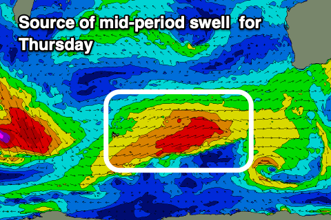
With this, a large mid-period SW swell is due to peak Thursday, mixed in with some distant groundswell though the models are combining the two and over-forecasting the size considerably.
We’re more likely to see surf in the 10ft range across the South West, 3ft Mandurah and 2-3ft Perth along with strong S/SE-S winds across all locations, cleaner Friday as winds ease and tend more SE in the South West, E/NE to the north.
Size wise the swell will be on the ease from 6ft to possibly 8ft in the South West, 2-3ft Mandurah and 2ft+ Perth.
Light winds are again due on Saturday but with smaller, leftover surf, while into the afternoon some moderate sized, long-range SW groundswell is due, likely peaking Sunday morning.
The source is a strong but tight and short-lived polar low forming south-east of South Africa this evening, producing a burst of severe-gale W/NW winds while tracking east-south east.
It’ll be inconsistent but should come in at 4-6ft across the South West Sunday morning, 1-2ft Mandurah and Perth along with poor, strengthening NW tending SW winds as a trough slides through.
The trough will likely bring some larger, localised windswell into Sunday afternoon/Monday but with onshore winds.
Longer term the run of onshore winds across the South West doesn’t look to let up with cleaner conditions across the metro locations, but more on this Wednesday.