Mostly average weekend, large and windy early next week

Western Australian Forecast by Craig Brokensha (issued Friday July 25th)
Best Days: Today, early tomorrow, Perth/Mandurah for the keen Tuesday morning
Features of the Forecast (tl;dr)
- Smaller tomorrow morning with moderate E/NE winds early, strengthening from the N/NE ahead of a shift to the N-N/NW into the afternoon
- Moderate + sized SW groundswell building later tomorrow, holding Sun AM
- Strong N/NW tending W then SW winds Sun (N/NE early Perth/Mandurah)
- Large mix of SW swells Mon with strong S-S/SW winds (S/SE for a period early to the north)
- Easing swell Tue with strong S winds (mod-fresh S/SE to the north in the AM)
- Smaller, weaker Wed with E/NE tending NW winds
Recap
Our large mix of swells peaked through yesterday with generally average conditions in the South West, workable in selected protected spots while Mandurah was fairly wind affected and not great either. Perth looked the best of it, but today is much better across all locations with lighter, more offshore breezes.
Metro regions are a good 3ft (bigger bombs Mandurah) with lumpy surf to 8ft across the South West.

Great surf later this morning
This weekend and next week (Jul 26 - Aug 1)
We’ll see the current swell continuing to ease into the weekend, with small leftovers due across the metro regions tomorrow morning to an inconsistent 2ft on the sets, while the South West looks to be the pick with sets to 4-5ft, easing through the day.
Local winds will be doable early and moderate from the E/NE, shifting N/NE and strengthening before going N-N/NW into the afternoon.
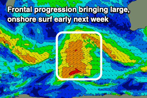
As these winds strengthen, a new long-period SW groundswell is expected to fill in, generated by a strong polar frontal progression across the Heard Island region earlier this week.
The swell should hit 6ft+ on the sets across Margs later with small 2ft waves to the north, holding a similar size Sunday.
Unfortunately Sunday will be a write-off as the next approaching frontal system moves in, bringing strong N/NW tending W then SW winds. Early Perth/Mandurah are due to see N/NE winds but with no major swell to worry about.
Looking at Monday and we’ve got a similar mixed swell event to Wednesday/Thursday just gone, with a strong, broad polar frontal progression expected to project a great fetch of sub-gale-force SW winds up and across us through Sunday afternoon/evening.
With this a large mix of mid-period and groundswell are due, though not to the size the models are showing. The South West should peak in the stormy 10ft+ range Monday, with building surf to 4ft+ across Mandurah, 3-4ft in Perth but with strong S/SW winds. Perth and Mandurah may see S/SE-S winds for a period through the morning.
A very slow improvement in winds and conditions are expected on Tuesday with strong S’ly winds persisting in the South West, moderate to fresh S/SE to the north along with easing surf from the 8ft range in the South West, 3ft+ Mandurah and 3ft Perth.
Wednesday will be the pick across the South West with a light E/NE offshore but smaller, leftover waves easing from 3ft+ or so, tiny to the north. So again the pattern looks similar to what we’re seeing now, with average winds for the peak of the swell across Margs.
Into the end of the week, strengthening N/NW-NW winds are expected with some new groundswell for Thursday, with a more significant Southern Ocean frontal progression expected to bring XL surf into next Saturday. More on this Monday, have a great weekend!