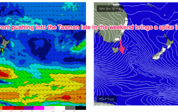
The whole synoptic pattern on the East Coast in the wake of Alfred is a moist onshore flow which looks to persist through into the mid week. A weak front races across the lower Tasman before reinforcing high pressure slips into the Tasman to reset the flow, albeit at a weaker level. Not a great deal of swell generated by any feature this week.
Primary tabs
/reports/forecaster-notes/sydney-hunter-illawarra/2025/03/10/small-mixed-bag-week-action-the-s-medium
freeride76
Monday, 10 March 2025
/reports/forecaster-notes/sydney-hunter-illawarra/2025/03/07/slowly-easing-surf-tc-alfred-onshore
freeride76
Friday, 7 March 2025
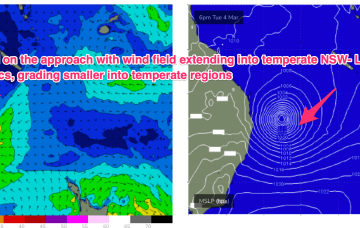
Depending on the movement of Ex TC Alfred we’re highly likely at this stage to see an increased NE-E/NE flow along the NSW Coast early next week as the remnants of the system drift down the Northern Tablelands.

/reports/forecaster-notes/sydney-hunter-illawarra/2025/03/04/plenty-size-the-wind-field-associated-tc
freeride76
Wednesday, 5 March 2025
Massive surf from the Moreton Bay Islands across the Gold Coast and down through Northern NSW will continue until the cyclone crossing, with much smaller surf on the Sunshine Coast and into temperate NSW. It’s been an epic event with a gnarly exclamation point expected as Alfred makes landfall.
/reports/forecaster-notes/sydney-hunter-illawarra/2025/03/02/plenty-swell-ahead-large-high-cradles-tc
freeride76
Monday, 3 March 2025
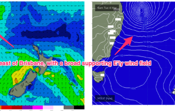
Alfred is expected to move SE today, generating mod to large swells down the NSW coast (it’s already solid in the sub-tropics!). Alfred takes a westwards turn thorough Tues into Wed and there’s now model consensus we’ll see a coastal crossing in SEQLD or far NENSW Thurs or Fri.
/reports/forecaster-notes/sydney-hunter-illawarra/2025/02/27/modest-surf-continues-short-term-while
freeride76
Friday, 28 February 2025
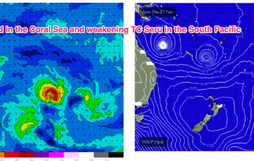
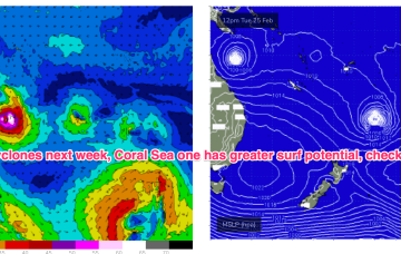
In the Coral Sea, Severe TC Alfred (currently borderline Cat4 central pressure 956hPa, expected to weaken to Cat 3 during the day) is crawling slowly SE to Southwards. TC Seru is SE of New Caledonia and weakening to tropical storm status through today as it slowly moves south-eastwards and then stalls.
/reports/forecaster-notes/sydney-hunter-illawarra/2025/02/26/complex-brew-three-cyclones-the-map
freeride76
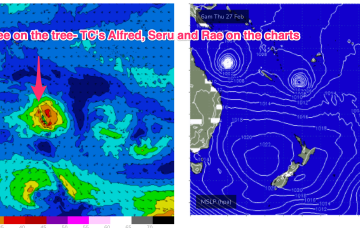
Wednesday, 26 February 2025
TC Alfred is in the Coral Sea, currently about a 1000km NE of Mackay and slow moving, expected to slowly track southwards from today. TC Rae has sped off SE to the graveyard and TC Seru is located between Vanuatu and Fiji and moving S/SE. In this complex brew, we’ll see multiple swell trains from the NE-E quadrant, although large swells are becoming increasingly unlikely as models firm on a coastal crossing for TC Alfred (still uncertainty over this track!) and the South Pacific cyclones track south-eastward, then eastwards as dissipating systems.
/reports/forecaster-notes/sydney-hunter-illawarra/2025/02/24/small-fun-summer-surf-two-cyclones-in
freeride76
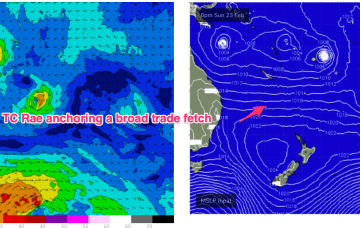
Monday, 24 February 2025
A very long and broad tradewind fetch is anchored on a NW/SE axis by twin tropical cyclones. TC Alfred is meandering in the Coral Sea NE of Cairns, while TC Rae is NW of Fiji and moving south-south westwards.
/reports/forecaster-notes/sydney-hunter-illawarra/2025/02/20/small-and-mediocre-short-term-fun-summer
freeride76
Friday, 21 February 2025
The monsoon trough is still active with a tropical low off the N.QLD coast and lows in the South Pacific through the Island chains. Medium term surf potential rests on these tropical lows, with the supporting tradewind belt supplying plenty of energy in the interim, focussed on the sub-tropics short term.
/reports/forecaster-notes/sydney-hunter-illawarra/2025/02/19/small-mixed-bag-ahead-while-we-wait-the
freeride76
Wednesday, 19 February 2025
Following that, we’ll see a fallow period while we wait for the next round of Tradeswell to develop next week, possibly enhanced by tropical low pressure systems in the South Pacific and Coral Sea.

/reports/forecaster-notes/sydney-hunter-illawarra/2025/02/17/plenty-great-waves-the-way
thermalben
Monday, 17 February 2025
To clarify further, I’m not revising my size estimates as such, it’s just that the fetch around the low - which should be pushing 50kts as we speak - is aimed away from the NSW coast so we’re looking at sideband energy glancing the coast later today and into Tuesday.
