A few changes to the outlook for the weekend, but in general I’m still anticipating better surf early next week.
Primary tabs
/reports/forecaster-notes/sydney-hunter-illawarra/2025/01/15/stacks-swell-and-wind-the-short-term
thermalben
Wednesday, 15 January 2025
/reports/forecaster-notes/sydney-hunter-illawarra/2025/01/13/large-swells-ahead-complex-tasman-low
thermalben
Monday, 13 January 2025
Main features on the synoptics this week are an approaching front from the west, a strong high just west of New Zealand and a deepening surface trough in the northern Tasman Sea - the latter of which will feed additional moisture into an already-evolving dynamic setup.

/reports/forecaster-notes/sydney-hunter-illawarra/2025/01/10/small-and-surfable-short-term-dynamic
freeride76
Friday, 10 January 2025
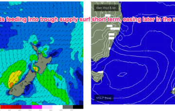
GFS suggests the inland trough moves Northwards, with a trough spawning a small low east of Tasmania and rapidly deepens o/night into Fri with strong winds to gales developing off the south coast and Bass Strait.

/reports/forecaster-notes/sydney-hunter-illawarra/2025/01/07/make-the-most-whats-offer-in-the-short
freeride76
Wednesday, 8 January 2025
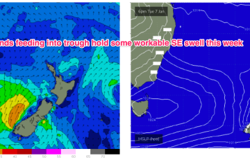
A small trough of low pressure has stalled off Seal Rocks with a SE infeed south of the trough expected to ease over the next 24 hrs and a light/variable flow north of the trough.
/reports/forecaster-notes/sydney-hunter-illawarra/2025/01/05/workable-weak-the-first-significant
freeride76
Monday, 6 January 2025
The current synoptic situation has a Groundhog Day feel to it, with another very weak high pressure cell in the Tasman (1019hPa), directing a mod N’ly flow along the temperate NSW coastline, with a weak Tradewind flow in the Coral Sea
/reports/forecaster-notes/sydney-hunter-illawarra/2025/01/02/small-waves-the-weekend-starting-see
freeride76
Friday, 3 January 2025
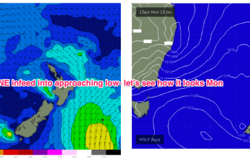
Further ahead and we have a dynamic outlook on the cards. An inland low and trough - a hybrid monsoonal feature- looks to approach the NSW coast, with a strengthening NE infeed into the system.
/reports/forecaster-notes/sydney-hunter-illawarra/2024/12/31/ne-windswells-ahead-flukey-s-swell-in
freeride76
Wednesday, 1 January 2025
Sun looks like more energy, especially south of Sydney, as NE windswell builds in response to a strengthening N/NE flow as high pressure and an approaching trough combine.
/reports/forecaster-notes/sydney-hunter-illawarra/2024/12/30/very-quiet-outlook-minor-windswells
freeride76
Monday, 30 December 2024
Very weak pressure gradients in the Tasman and Coral Seas as we count down 2024.

/reports/forecaster-notes/sydney-hunter-illawarra/2024/12/27/small-bits-and-pieces-end-the-year
freeride76
Friday, 27 December 2024
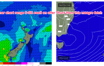
The trough which brings a S’ly change tonight has a brief proximate fetch of strong S-S/SE winds o/night which whips up some local S-SE windswell for Sat. No great size or quality involved.
/reports/forecaster-notes/sydney-hunter-illawarra/2024/12/25/easing-swells-quiet-end-2024
freeride76
Wednesday, 25 December 2024
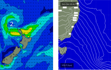
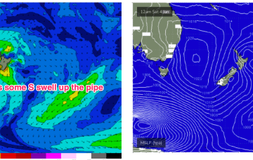
A deep low is moving slowly towards New Zealand but the main bulk of the fetch has already rotated away from the East Coast with an off axis fetch aimed at South Pacific Islands. Elongated high pressure is moving into the Tasman with an approaching trough, front and cut-off low expected to tighten the pressure gradient leading to freshening N’lies from Boxing Day.
