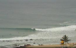
We should see some good waves across most coasts this weekend.
Primary tabs
/reports/forecaster-notes/south-east-queensland-northern-new-south-wales/2016/08/05/fun-weekend-surf
thermalben
Friday, 5 August 2016
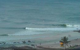
/reports/forecaster-notes/south-east-queensland-northern-new-south-wales/2016/08/03/southerly-gales
thermalben
Wednesday, 3 August 2016
Thursday is all about the strength of the southerly wind: we’re looking at 30-40kts+ at exposed coasts, and 20-30kts elsewhere.
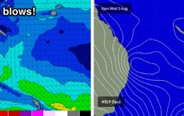
/reports/forecaster-notes/south-east-queensland-northern-new-south-wales/2016/08/01/late-wednesday
thermalben
Monday, 1 August 2016
There’s a chance that some locations in Far Northern NSW could see a window of excellent large surf as the swell starts to build later Wednesday.
/reports/forecaster-notes/south-east-queensland-northern-new-south-wales/2016/07/29/easing-sly-swell
thermalben
Friday, 29 July 2016
The strong southerly groundswell currently pushing up along the Northern NSW will probably peak overnight, which is a shame as there’s a lot of size and strength in the water right now.
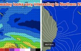
/reports/forecaster-notes/south-east-queensland-northern-new-south-wales/2016/07/27/solid-south-swell
thermalben
Wednesday, 27 July 2016
Friday still looks very interesting, with a very powerful front/low expected to track under Tasmania late Wednesday
/reports/forecaster-notes/south-east-queensland-northern-new-south-wales/2016/07/25/solid-sly-swell
thermalben
Monday, 25 July 2016
Today saw very strong lines of S’ly swell in Southern NSW, and because of the origin, direction and trend, we can be reasonably confident that this swell will push across Northern NSW too.
/reports/forecaster-notes/south-east-queensland-northern-new-south-wales/2016/07/22/many-pulses-south
thermalben
Friday, 22 July 2016
This means we won’t see the resulting new southerly swell push up the Northern NSW coast until sometime Sunday - probably early to mid morning on the Mid North Coast, then early to mid afternoon across the Far North Coast.
/reports/forecaster-notes/south-east-queensland-northern-new-south-wales/2016/07/20/mixed-bag-se-and
thermalben
Wednesday, 20 July 2016
A weak trough pushing off the NSW coast this evening now looks like it’ll display a minor E’ly thru’ SE fetch off its southern flank into tomorrow. This should generate a brief SE swell for Thursday though I can’t see anywhere north of about Coffs receiving much influence from it.

/reports/forecaster-notes/south-east-queensland-northern-new-south-wales/2016/07/18/small-south-swell
thermalben
Monday, 18 July 2016
The synoptic charts make for pretty grim reading.
/reports/forecaster-notes/south-east-queensland-northern-new-south-wales/2016/07/15/mixed-bag-surf
thermalben
Friday, 15 July 2016
The final southerly pulse in this recent series is pushing up the Southern NSW coast today and will peak overnight or early Saturday across Northern NSW.