Easing S'ly swell Saturday, fresh S'ly swell Sunday, then lots of potential for the second half of next week

South-east Queensland and Northern NSW Surf Forecast by Ben Matson (issued Friday 29th July)
Best Days: Sat: solid but steadily easing S'ly swell in Northern NSW (only small in SE Qld). Sun: building S'ly swell during the day in Northern NSW, with early light winds and a'noon sea breezes (only small in SE Qld). Mon: small easing S'ly swell in Northern NSW with good winds early. Wed thru' Sat: series of solid, potentially large S'ly swells, but mainly in Northern NSW (likely to be small in SE Qld due to the swell direction).
Recap: Thursday saw a small S’ly swell build across south facing beaches in Northern NSW, with 2-3ft sets at times. SE Qld remained tiny to flat. Today we’ve seen a stronger S’ly groundswell build across Northern NSW, and south facing beaches across the Mid North Coast are now pushing the 4-6ft mark (with the swell also building across the Far North too). Judging by surf observations in southern NSW, we may still have a little more size to come too, with a likely peak overnight. However, surf size is still tiny across SE Qld.
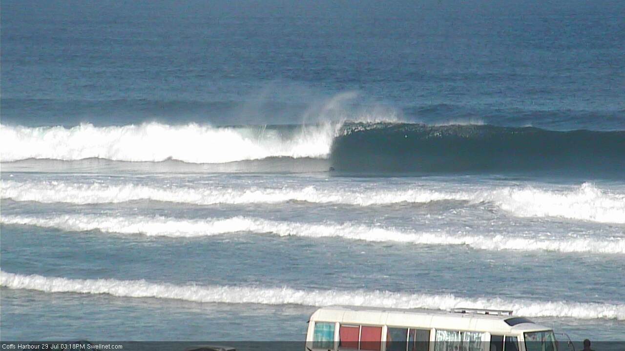
Decent mid-afternoon sets starting to show in Coffs Harbour, and it's still getting bigger
This weekend (Saturday 30th - Sunday 31st July)
The strong southerly groundswell currently pushing up along the Northern NSW will probably peak overnight, which is a shame as there’s a lot of size and strength in the water right now.
However, early Saturday morning should still have a fair amount of size at south facing beaches; specifically south of Byron but north of Coffs.
The reason for this narrow focus of maximum surf size, is that due to today's south swell originating from latitudes south of the mainland, more southern locations will see an easing trend first (i.e. Mid North Coast before the Far North Coast).
But on the other hand, the coastal alignment north of Byron Bay - and in particular, north of the border - is unfavourable for these kinds of southerly swells. So we’re looking at smaller surf along the Tweed Coast, and very small surf continuing throughout SE Qld (though, it should be marginally bigger than what we saw earlier today).
Add in the expected easing trend and you’ll have to aim for an early surf to maximise your chances of any notable size.
The good news is that local conditions should be nice and clean for the dawn patrol on Saturday with generally light offshore winds. A weak pressure gradient is expected throughout the day so sea breezes are likely after lunch.
South facing beaches from Byron to Coffs should see early 4-5ft sets (easing during the day), with 3-4ft surf south from Coffs, and smaller waves at beaches not completely open to the south.
North of Byron we’re looking at inconsistent 3ft surf along the exposed Tweed Coast beaches, then maybe inconsistent 1ft+ surf across most Gold and Sunshine Coast beaches. The outer points should see very occasional bigger sets early morning, and SE Qld’s handful of south swell magnets may rake in a few stray 2-3ft sets at first but it’s likely to be very infrequent, so with an easing trend expected during the day your best chances of a wave will be south of Byron on Saturday morning.
A strong new front pushing into the lower Tasman Sea later today will generate another burst of south swell for the NSW coast on Sunday. The leading edge of this pulse is expected to nose into the Lower Mid North Coast in the early hours of Sunday morning and the Far North Coast mid-late morning. So, many beaches may only see small residual swell early Sunday with light offshore winds (this is the reverse of the trend description above - southern locations will see the new south swell earlier than northern locations).
Wave heights will build throughout the day, and we’re looking at (once again) a very late peak in size across south facing beaches south of Byron, with sets in the 3-4ft+ range.
Remaining beaches not directly open to the south will be smaller in size, and SE Qld will dip out in the size department from this event; its potential will be hampered not only by directional deficiencies, but also by a likely late afternoon upwards trend north of the border.
Again, light offshore winds through the morning will probably give way to afternoon sea breezes, so Sunday’s a dicey call - small but clean surf early on, or bigger building south swell into the afternoon but with the possibility of a moderate bumpy nor’easter.
Saturday morning is therefore the pick of the weekend.
Next week (Monday 1st August)
Sunday’s late new swell won’t hang around for long so we’re looking at an easing trend into Monday from the south.
Most south facing beaches south of Byron should see early 2-3ft+ sets but it’ll likely ease to an inconsistent 2ft+ by lunchtime. Aim for an early session as light offshore winds will quickly swing northerly then moderate to fresh north-east into the afternoon.
Freshening NW winds are then expected on Tuesday with the south swell all but bottoming out across even the most exposed coasts. Tuesday looks like a lay day at this stage, though conditions will be clean if you’ve got a high volume board and a relaible south swell magnet at your disposal.
As this is happening, a broad, complex low pressure system will be developing across the southern Tasman Sea, stretching halfway down to Antarctica. This is expected to generate a significant round of new swell for the second half of next week.
In fact, the specifics for the longer term outlook are a little tricky because right now, the models have the low’s western flank very close to the southern Southern NSW coast - if they shunt it a couple of hundred kilometres west (plausible, seeing that we’re still four days from its evolution), then we won’t see much, if any swell from it.
That being said, the sheer size and magnitude of this system - and its slow eastward track - means it's very likely to develop favourable swell generating characteristics for us next week.
To begin with, we're looking at one or two days of SW tending S’ly gales off the Southern NSW coast from late Tuesday through Wednesday and probably Thursday. Also, as we progress through the week we’ll also see the southern flank of the low - well south-east of Tasmania - start to come into effect as it slingshots cold fronts around the primary low, generating stronger, better aligned southerly groundswell for the region.
The upshot of this is that we have a series of punchy short range, but flukey south swells on the cards for Northern NSW at some point on Wednesday and (more likely) Thursday, with any time from late Thursday thru’ Friday and maybe even Saturday potentially the target of a sizeable series of powerful southerly swells. However, we’ll have to wait and see how the model guidance pans out over the weekend. I’ll comment below as more information comes to hand.
And unfortunately for Queensland surfers, these next swells look like they probably won't favour anywhere north of the border either. Still got that fuel card handy?
Have a great weekend, see you Monday!
Comments
Thanks for the update Ben, hope you score a few yourself this weekend!
Thanks mate.
Our surfcams randomly capture one still image every ten minutes.
How's this grab from Coffs Harbour a short time ago?
Can attest to coffs this arv. Don't think it can handle much more in the size department, so hopefully sunday's swell is similar sized.
I reckon it'll be a couple of feet smaller. Still pretty strong, maybe 4ft+ sets but not at the range seen this arvo.
That'll be good - the bombs were just washing through. This morning was fun, but the S component kicked in relatively early.
Fun classy head high waves on the Tweed Coast this morning. Swell seems a little slow and the beachies don't have many banks, but it's hard to knock this glorious winter weather.
Jeez, it's tiny across the Gold Coast.
But.. D'Bah's picking up some lines and there's still a few reasonable waves at south facing beaches.
Coffs still has a few solid sets too, seems to be in the 4ft range.
Weak seabreezes (E/NE) are now across SE Qld and winds are moderate from the S thru' S/SW across Northern NSW, so surface conditions could be a little ruffled at some spots for the next few hours. Maybe a late glass off if we're lucky though wave heights will trend down later.
Sunny Coast swell magnet had 2ft sets this morning. Long wait but fun when they arrived. Small wave board earning its keep lately.
I was impressed by this SUP rider at Moffats who rode this line of unbroken swell from way out the back all the way into the shore this morning.
Hi Ben, I understand the numbers on the forecast page sometimes get over cooked, but in relation to SEQ, would it be fair to say an upgrade is in order from Thursday? Like everyone else I'm hanging to surf something decent, hope this is it.