Late Wednesday options in Northern NSW; then three days of great waves across the SE Qld points

South-east Queensland and Northern NSW Surf Forecast by Ben Matson (issued Monday 1st August)
Best Days: Tues: small clean waves in Northern NSW. Wed: tricky due to an advancing S'ly change, but a chance for a late pulse of large clean surf in Far Northern NSW (wind affected across the Mid North Coast, and maybe too small/too late across SE Qld). Thurs/Fri/Sat: strong S/SE swells with gusty S'ly winds, ideal for the SE Qld points. Sun: renewal of strong S'ly groundswell but winds look tricky.
Recap: Friday’s large S’ly pulse late in the day eased steadily through Saturday though south facing beaches south of Byron still had some strong sets early morning around 4-5ft. Surf size remained very small across SE Qld. A new S’ly pulse then pushed across Northern NSW on Sunday, offering 3-4ft sets at south facing beaches but remaining tiny in SE Qld due to the swell direction. Today we’ve seen easing S’ly swell right across the region with - you guessed it - tiny conditions in SE Qld once again.
Oh, did I mention out that we have a new surfcam at Alex Headland? And one at Kingscliff too? Check them out here: https://www.swellnet.com/surfcams/alex-headland, and https://www.swellnet.com/surfcams/kingscliff
(PS.. there's more new surfcams to come too)
This week (Tuesday 2nd - Friday 5th August)
So, there are essentially no new swell sources in the region for Tuesday.
This means a further slow drop in size from today, with moderate NW winds keeping conditions clean at the open beaches. I can’t see there being much value north of the border, so aim for an exposed south swell magnet south of Byron for the best size potential.
In Friday’s notes, I discussed a complex Tasman system expected to develop during the middle of this week. Over the weekend, the models went berko, progging a huge series of southerly swells for Southern NSW that would have likely left quite a mark on Northern NSW too.
However today we’ve seen the models shift around considerably. And now that we’re just a few days away from its genesis, it’s looking like we can start to bed down some plans. In short: the Far Northern NSW and SE Qld is in for somewhat of a battering.
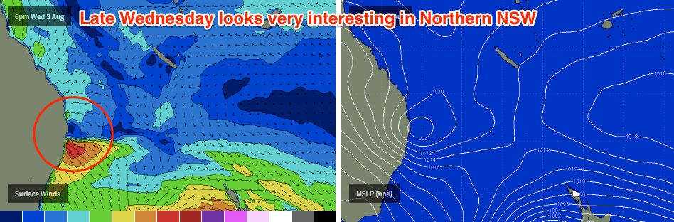
A strong front will push up the NSW coast on Tuesday, but it’s expected to stall near the border into Wednesday morning, forming a closed low which will then intensify off the Far Northern NSW coast.
What’s tricky about this system is that it's currently expected to remain almost stationary through much of Wednesday. As such, locations north of the trough’s axis will see a westerly outflow (ie SE Qld), whilst locations to the south will see anywhere from gale force SW winds (right near the trough) through S’ly then SE (further south). At this stage it appears the axis will lie somewhere between Yamba and Ballina though we’ll have a better idea as we draw closer.
And this is crucial for surf prospects, because although conditions will be terrible south of the axis, we’ll see clean conditions to the north - and a generous percentage of surf size too, in short proximity to the axis.
So there’s a chance that some locations in Far Northern NSW could see a window of excellent large surf as the swell starts to build later Wednesday.
Initially, I think the primary swell energy will be focused south of the border so any new surf we see (before Thursday) will be much, much smaller north of the border. But that doesn’t mean Wednesday afternoon won’t have some potential across SE Qld beaches and outer points - they’ll be clean under the offshore breeze. It’s just that it will be significantly smaller than locations south of the border (with a later arrival time too, which also reduces surf prospects).
So, my expectations for the size trend on Wednesday will be upwards all day in Northern NSW, starting from a small base (especially in the north). I’m not too worried about size prospects across the Mid North Coast as local conditions really aren’t looking too flash (though the protected points here should see good waves into the afternoon); my main area of attention is Far Northern NSW between Yamba and Byron where we could be looking at a late pulse to 4-6ft+ at open beaches, with smaller waves at sheltered locations.
North of Byron, surf size will likely be smaller and across SE Qld I think will see tiny conditions for most of the day, with an outside chance for some late 2-3ft sets in the last hour or two of the day at open south facing beaches - but mainly the Gold Coast rather than the Sunshine Coast.
So, into Thursday and it looks like the low will move slowly northwards over the border, extending southerly gales into SE Qld. This should generate a strong local swell for the outer points (4-5ft+), with larger 6ft+ sets at south facing beaches - though they’ll be horribly wind affected.
Keep in mind that sheltered inner points (i.e. Noosa) will remain very small due to the strong southerly component in the swell direction.
Across Northern NSW, strong local S’ly winds will render all but the most sheltered locations very ordinary. However exposed beaches should see some large stormy surf upwards of 6-8ft in the Far North, with smaller surf across the Mid North.
And then as we head into Friday, we should start to see a plateau in swell energy across the region, with fresh strong S’ly winds (maybe SW early, but tending S/SE during the day). Open beaches and outer points across SE Qld should pick up anywhere between 4-6ft, and strong 6ft+ sets at south facing beaches. South of the border may see slightly larger waves down to about Yamba but with slightly smaller surf through to Seal Rocks - but they’ll continue to be wind affected form the SE, pushing the best waves to sheltered points and southern corners.
So in summary, Wednesday afternoon has some potential across Far Northern NSW for a late pulse of strong, clean swell, whilst Thursday and Friday are looking great for the SE Qld points with one of the biggest swells in many months.
This weekend (Saturday 6th - Sunday 7th August)
Whilst all of this is going on, there will have been several other swell sources develop in other swell windows. Though, it’s hard to alter focus when there's a significant weather system on your doorstep.
A low off the West Coast of New Zealand’s South Island mid-week will generate some moderate SE swell into the mix on Friday. This swell - as well as the others contributing to Friday’s energy - will then ease through Saturday. Unfortunately local winds are expected to remain moderate to fresh SE so protected locations will be the primary focus, again with SE Qld being the pick.
However, a much better swell is then expected to arrive on Sunday. A polar low is due to track in a straight meridional alignment through the central/eastern lower Tasman Sea around Thursday, pushing up a strong S/SE swell that’s due to reach Southern NSW on Saturday, and Northern NSW on Sunday. At this stage I’m expecting sets up to 6ft+ at exposed south facing locations south of Byron, though we’ll still be at risk of a SE breeze.
This swell will be much smaller in SE Qld however unlike recent S’ly swells, this one should be more than enough to maintain fun waves across the outer points at least (say, 2-3ft+). So there’ll be plenty of waves north of the border this weekend.
Next week (Monday 8th August onwards)
Once the weekend’s swells slowly subside through Monday, it appears that we’ll settle back into a quieter period for a few days.
That being said, the long term models are suggesting our easterly swell window could fire up early-mid week, leading to an increase in easterly swell later next week. More on this in Wednesday’s update.
Comments
Wow, what a synoptic setup!
Hows the sand going up there. Can remember there been some grim reports after the big NE swell. No im not planng up a trip up anytime soon.
Sand looks great lately just been waiting for a decent swell to see it perform. Looks like it will be ruined again before that happens.
Yip there are a few spots firing at thew moment, these big swells can do more harm than good sometimes
Hi Ben
At what stage on Wednesday do you think there might be a bump in the swell size between The border and Byron (South Facing beaches?) Do you think the trend will rise from mid morning or more likely mid afternoon? I can take one day off this week so planning for the best day. Trying to avoid the human soup of the goldie points if possible
Honestly you northern rivers people whingeing about swell. This is a blessing, So I hope it busts your banks to shit, and we (sunny coast) get 2-3 foot.
"biggest swell in many months" and your concerned over the banks?? Fucking what do you want a wave pool?
"in short proximity to the axis"............
Yippee
Thanks Ben....you are the best
On the Mid nth coast what direction will the swell be? E/NorEast?? If so what size are we looking @ down near seals Rocks? S/east winds or E/sou/east???
Ben...why isn't the new Alex surfcam listed under surf cams?
BTW great angle!
A minor coding issue, will be fixed shortly. Plus another SC cam this arvo too :)
Stoked you like the angle, wait till you see the next cams!
where will it be Ben ? the suspense is killing me, I'm guessing Coolum.
I should really subscribe to PRO !!!
Not quite Coolum, not quite Kings either haha.
https://www.swellnet.com/surfcams/kings-beach
Christ on a motherfucking stick, not another bank buster.
Just as the sand was starting to come back.
This winter is going from mediocre (apart from the June black nor-easter swell) to diabolical.
Hopefully it'll at least get the jewies on the chew off the walls.
My thoughts exactly, a little bit north of you and out the front of mine is just starting to look pristine sand wise for first time since June swell. Oh well glad I got a couple of 2 footers on it over the weekend
Bummer, it's been great down here.
Surpassed autumn by a long way. It did that in the first week though with the black nor'easter event.
Geez I know its a long way out, but the most recent model run for Sunday 14th onwards looks mental. 'We're going to need a bigger boat'.
Please please please let the Sunny coast catch a few!
HA HA HA. waxy feet wax them feet. we are in the zone. Let them whinge and bitch about bank busting.
Light W here, still a northerly biased inflow at Coolangatta, SE/SSE at Coffs. Couple of storm cells passing in the night but only a light sprinkling of rain here.
Looks like's it's spinning up somewhere between Evans and the yuraygir coast.
Please don't move North.
Def moving north, looking to hit between 10pm this evening and 1am tomorrow IMO.
Looks like the low is located a little further south than models expected on Monday. Surf is solid across the Mid North Coast but there's not much showing in Far Northern NSW.. yet. Still some time to go though for a late pulse.
Starting to build near seals few fun one around out of the wind if u look. Farrrk rather be in boardies in the troipcs