Easing surf on the weekend with light winds

Victorian Forecast by Craig Brokensha (issued Friday August 8th)
Best Days: Today, tomorrow, Sunday exposed beaches, Monday and Tuesday morning exposed beaches
Features of the Forecast (tl;dr)
- Easing SW groundswell tomorrow with light E/NE-NE tending variable winds
- Smaller Sun, with a new, inconsistent W/SW groundswell under N/NE winds and late sea breezes
- Slightly smaller, inconsistent W/SW groundswell Mon, similar in size Tue
- NE tending E/NE winds Mon
- Fresh to strong N/NE tending N/NW winds Tue
- Small Wed with W/NW tending SW winds
Recap
The surf was generally average yesterday morning with our first pulse of SW groundswell not really amounting to much over 3ft on the Surf Coast with 5ft sets to the east with a lot of noise in the mix under morning W/NW winds.
A SW change into the afternoon didn’t affect conditions too adversely and this morning we’ve got much better surf with our secondary pulse of SW groundswell filling in with variable winds.
The Surf Coast is a consistent 4-5ft+ while the exposed beaches are large to the east and these winds will remain variable ahead of weak sea breezes.

A little lumpy but with much better size today
This weekend and next week (Aug 9 - 15)
Today’s strong pulse of SW groundswell is due to slowly ease over the weekend, with the exposed beaches likely still coming in too big, dropping from the 6ft range with 4ft sets on the Surf Coast tomorrow.
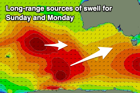
Sunday will be a little smaller though our reinforcing SW groundswell that’s expected to arrive through the day is still on track, generated by a fetch of pre-frontal N/NW-NW gales at the head of a stronger polar low that formed around the Heard Island region mid-week.
This should maintain 2-3ft sets on the Surf Coast with 4-5ft waves to the east, though inconsistent.
Looking at the local winds, a light E/NE-NE breeze is due tomorrow morning, becoming variable through the day with possible weak sea breezes, with Sunday seeing great N/NE winds, giving into weak, late sea breezes.
Into Monday, the long-range W/SW groundswell from the Heard Island low is expected, and size wise it looks similar to Sunday but a lot less consistent and mostly 2ft across the Surf Coast and 4ft to the east.
NE tending E/NE winds will favour the beaches again with Tuesday coming in a touch smaller under fresh to strong N/NE tending N/NW winds as weakening mid-latitude frontal systems start edging in from the west.
This weakening activity will generate small pulses of weak W’ly swell energy through the week but it doesn’t look to top 1-2ft on the Surf Coast with a bit more size to the east. W/NW tending SW winds will favour the Surf Coast Wednesday with a temporary return to NE winds Thursday.
Longer term the outlook remains so/so, with the only chance of some decent swell arriving from a funky mid-latitude low drifting in later week. More on this Monday, have a great weekend!
Comments
Tomorrow be like 2ft tops?