Upgrade in westerly swell next week
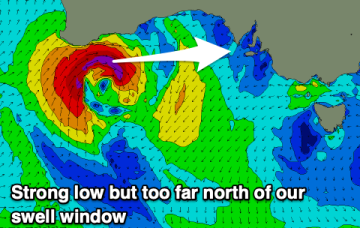
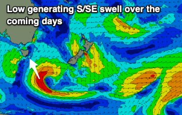
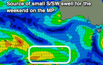
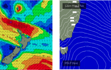
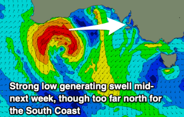
A severe low will form off the Western Australian coast and drift into our swell window Monday, generating a sizey westerly groundswell.
Winds will come out of the east to north-east over the coming days but with small levels of weak swell.
The main feature of the forecast period of a gusty southerly change that’s already arrived in Southern NSW, and will push across the Mid North Coast overnight, reaching Far Northern NSW mid-late morning and the Gold Coast around lunchtime.
As mentioned on Monday, we've got an unusual synoptic pattern setting up in the Tasman Sea.
A mix of swells over the coming days but mainly easing from the east-northeast and pulsing from the south.
There'll be plenty of surf from the south to south-east over the coming days with improving winds into the weekend.
There's a fun swell with clean conditions to end off the week, deteriorating through the weekend with a large stormy swell early next week.
Slowly improving conditions but with easing surf in size and energy, bottoming out once cleanest.
A slow moving high will see winds slowly improving and swinging anti-clockwise over the coming period but with minimal levels of swell.
This extended run of quality point break surf means there's a chance for the crowds to spread out over the course of the week which, combined with a consistent, super-charged trade swell event, should allow a (relatively) healthy wave count for all and sundry.