Sustained period of sizeable, windy conditions ahead

South-east Queensland and Northern NSW Surf Forecast by Ben Matson (issued Wed 2nd Feb)
Forecast Summary (tl;dr)
- Brief window of light winds and small leftover beachies north from Yamba early Thurs (persisting longer in SE Qld)
- Very windy conditions devloping Thurs, persisting until Mon
- Large combo of S'ly and SE swells from Fri thru' Mon
- Better conditions from Tues onwards with lighter winds and a mix of strong SE and E swells
Recap
Some unreal waves were reported across the board on Tuesday, from 4-5ft in SE Qld up to 6-8ft at a few select locations along the Mid North Coast. Everywhere else was somewhere between, and generally light winds from the north didn’t seem to cause too many problems. Today we’ve seen generally similar conditions though wave heights eased back and the morning high tide didn’t assist a lot of locations. Early 3-4ft sets north of the border eased slowly through the day, and bigger 4-5ft surf was reported throughout Northern NSW. Heavy rain is starting to impact SE Qld as a surface trough moves over the region.
This week (Feb 4 - 5)
The main feature of the forecast period of a gusty southerly change that’s already arrived in Southern NSW, and will push across the Mid North Coast overnight, reaching Far Northern NSW mid-late morning and the Gold Coast around lunchtime.
This change will strengthen as it moves north, so although surface winds in Sydney are generally 20-25kts this afternoon, we may see 30-40kts across some of the more exposed coastal regions (such as Byron Bay) later Thursday and overnight into Friday.
Ahead of the change, winds will be light and this will be your best time to capitalise on small beach breaks showing leftover E’ly energy from the last few days. In fact the Sunshine Coast may not see the S’ly change until mid-afternoon, with NW winds through the morning.
Expect size around the 2ft+ mark at exposed locations north of the border, and 2-3ft+ south of the border, but with a limited window of opportunity as you head south from Yamba.
Once the S’ly kicks in it’ll be victory at sea for the rest of the day, in fact Friday will continue this trend as the wind veers more S/SE.
A strong high in the Bight ridging in from the west will tighten the pressure gradient between it and a complex deepening surface trough encompassing the bulk of the Tasman Sea, responsible for Thursday’s southerly change.
In fact, we are expecting the creation of several low pressure centres along the trough line, off the NSW coast. Indeed, there’s already a large mid-latitude-cum-polar low sitting south-east of Tasmania, with southerly gales on its western flank generating new southerly groundswells that’ll pad out the next few days (mainly southern regions).
However, local systems just off the coast - and their associated southerly fetches - will generate additional short range swell trains that will mix in to create a noisy surf zone environment.
The upshot of this is a sustained period of windy, building S’ly and S/SE swells on Friday that should reach a stormy 5-6ft+ at south facing beaches south of Byron, though much smaller on the points and inside sheltered southern ends.
The protected SE Qld points will handle the wind much better, but the initially low periods and steep southerly direction will limit heights - increasing from 2ft early Friday to 3-4ft+ by late afternoon. Exposed northern ends will be much bigger but out of control with these winds.
Keep your expectations pegged a little lower than normal, short range southerly swells are flukey beasts.
This weekend (Feb 6 - 7)
As mentioned on Monday, we've got an unusual synoptic pattern setting up in the Tasman Sea.
Unusual in that it’s a broadscale blocking pattern that looks like it’ll anchor a fetch of S/SE gales from the SW tip of New Zealand up into Far Northern Queensland for a couple of days (see below) - a theoretical distance of about 3,500km.
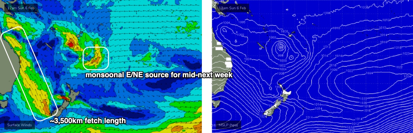
Of course, only the lower two-thirds of this fetch is useful for Northern NSW, and the direction isn’t perfect for SE Qld, and wind speeds aren’t expected to be outrageously strong - however its stationary nature means we can bump up projected wave heights compared to a mobile fetch of similar characteristics.
The latest model runs have pushed the whole pattern a little further south since Monday, which will shave off size throughout SE Qld compared to earlier predictions.
Regardless, it’s a weekend only suitable for sheltered points, as exposed beaches will be too big and wind affected.
An intensifying low (along the trough line) in the Central Tasman on Friday will probably deliver an embedded pulse of bigger waves, in what’ll otherwise probably be a sustained period of 5-6ft+ surf for Northern NSW, and 4-5ft at exposed SE Qld locations, smaller on the points. This embedded pulse is due early Saturday and should nudge the 6-8ft+ mark south of the border, and maybe 6ft+ across SE Qld, though the points will be smaller in size (say, 4-5ft southern Gold Coast, smaller at sheltered Sunny Coast points),
Throw in a strong northerly sweep (south to north) and options will really be limited to those handful of locations that can handle the size and the wind.
Again, I’d keep your expectations low for the weekend as there simply won’t be many locations offering workable options.
Next week (Feb 8 onwards)
While all of the above is going on, a strong monsoon pattern will be pushing east from the tropical Queensland coast through the Coral Sea and stretching out into the South Pacific, possibly resulting in the development of a tropical cyclone or two, but more importantly injecting significant amounts of energy into an already dynamic setup in the Tasman Sea.
This is expected to retrograde a surface low pressure system at the bottom end of the Tasman trough later Sunday and into Monday, moving west from New Zealand back towards the Southern NSW coast, working on the already-active sea state generated by three days of an anchored S/SE fetch.
This pattern won’t actually favour Northern NSW and SE Qld swell-wise, as the fetch will be mainly aimed into southern regions. However, it should bring about a period of lighter winds from about Tuesday onwards.
So, at this stage expect very large and windy but gradually easing leftover surf on Monday, before a solid but much more moderate mix of SE and E’ly swells pad out the middle of the week, still somewhere in the 4-5ft+ range at exposed spots with smaller clean options on the points.
For mine, that’ll be the best time to capitalise on this event.
The broad scale pattern remains very troughy through the latter part of next week so I’m expecting plenty of swell to persist from the eastern quadrant into the following week and beyond.
See you Friday.
Comments
Great report, well set realistic expectations.
Far out we have had so much swell for so long now it's been an excellent run
Random and off topic but that long southerly fetch conjures up thoughts of south shores of PNG and also Torres Straight Islands?
Anyone got any experience or knowledge of up there?
Nothing up there troppo cept crocs, boxes and irikundjies troppo. Ah, I forgot, the bloody stifling humidity as well. But if you are keen, a bit of volume will help as will the BALA vibe.
I don't think I remember the water being this warm for so long with no upwelling changes. I swear today was 27/28 degrees south of the border.
Hopefully Autumn doesn't run out of gas