Fun surf to end off the week

Western Australia Surf Forecast by Craig Brokensha (issued Wednesday February 2nd)
Best Days: Friday and Saturday morning in the South West
Features of the Forecast (tl;dr)
- Inconsistent SW groundswell arriving late tomorrow, peaking Fri with fresh E/NE tending N/NE then lighter N/NW winds
- Easing SW swell Sat with variable tending W/SW winds
- Small mid-period SW swell Sun with light S tending strengthening W/SW winds
- Large stormy W/SW-SW swell developing early next week with strong onshore winds, easing as winds slowly improve mid-week
Recap
Windy though improving conditions into the late morning and early afternoon across the South West yesterday with easing sets from the S/SW to 3ft. Perth and Mandurah were clean but tiny.
Today the surf is bottoming out with stronger offshore winds and nowhere to really recommend.
This week and next (Jan 3 - 11)
Tomorrow will start out near flat with strong E/NE winds but later in the day a new, inconsistent SW groundswell should arrive, peaking through Friday. This was generated by a distant, short-lived but broad low firing up south-east of South Africa, aiming a burst of W/SW gales through our swell window.
It'll be inconsistent with 4-5ft sets due across the South West Friday, tiny in Mandurah and Perth.
The swell will ease slowly from 3-5ft as a reinforcing swell softens the drop and winds look best Friday and moderate to fresh from the E/NE, shifting more N/NE late morning and lighter N/NW into the afternoon across the South West. Variable winds are due into Saturday morning ahead of a W/SW change as a trough moves through.
Smaller surf is expected into Sunday morning and and winds are looking better early with variable S winds, quickly strengthening from the W/SW through the day.
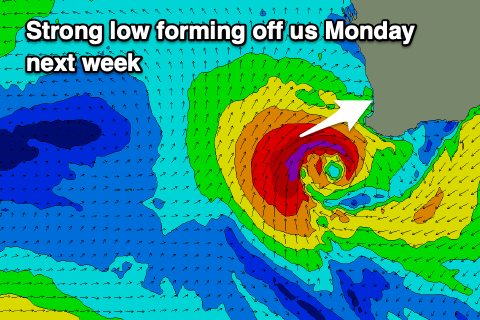 This strengthening wind will be linked to a weak mid-latitude front pushing in from the west, stalling off our south-west and forming into an intense low during Monday.
This will project a fetch of gale to severe-gale SW winds into the southern half of the state, kicking up a large, stormy W/SW-SW swell. The models diverge a touch regarding how long it will stay off our region, with longer it stalls, the bigger it'll get so we'll have to have a closer look at this on Friday.
Either way Mandurah and Perth will see waves, albeit with strong onshore winds, easing into Wednesday as winds go around to the S'th and ease.
Following this close-range swell the outlook remains slow but more on this Friday.