Still nothing significant on the radar- tracking some flukey sources next week

freeride76

Still nothing significant on the radar- tracking some flukey sources next week

freeride76

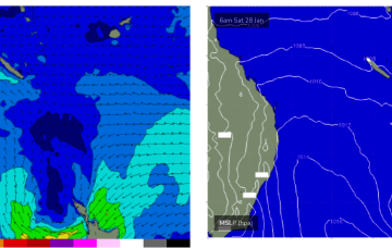
That's leading to continuing light winds in the Coral Sea and tiny surf. Models are suggesting a minor increase in SE swell tomorrow as the trade flow perks up just a notch but any increase will be very minor so keep expectations low with knee high waves expected at best. Maybe just surfable at exposed breaks.

Enough swell sources to keep things ticking along with tricky, troughy winds next week

freeride76

Enough swell sources to keep things ticking along with tricky, troughy winds next week

freeride76

Weak high pressure is rapidly moving SE into the Tasman in the wake of yesterdays trough, which has stalled just north of the Hunter coast. E’ly fetches are still bubbling away near the North Island with more small E quadrant  swell expected over the short/medium term. A long range, rare SSE-SE groundswell is just starting to show on Tasmanian buoys.

Tiny surf extending into the weekend and next week

freeride76

Tiny surf extending into the weekend and next week

freeride76

The synoptic pattern over and surrounding Australia still has a strong La Niña signature with troughy low pressure areas in the Tasman Sea and an active monsoon trough across Northern Australia. High pressure on the other side of New Zealand is cradling areas of low pressure aimed at NSW and SEQLD with the Coral Sea adjacent to the CQ swell window offering up very weak pressure gradients and swell generating winds.