Options for a small wave most days

Southern Tasmanian Surf Forecast by Craig Brokensha (issued Monday January 23rd)
Best Days: Tomorrow morning, selected spots Friday, beginners Saturday selected spots, Tuesday morning, Wednesday morning
Features of the Forecast (tl;dr)
- Inconsistent W/SW groundswell building today
- Inconsistent mid-period W/SW swell Thu/Fri, easing Sat
- W/NW tending SW-S/SW winds late AM Thu, fresh N/NE tending strong NE winds Fri
- Inconsistent small SE groundswell Fri, easing Sat
- Strong N/NE winds Sat, tending N/NW ahead of a late SW change
- Late increase in mid-period W/SW swell Mon with N tending E/NE, then SE winds
- Better W/SW groundswell building Tue PM with NW tending SE winds
- Easing swell Wed with W/NW tending S/SW winds
Recap
The surf was still hanging in at 1-2ft yesterday morning, better than expected and today the surf was again 1-2ft with the arrival of an inconsistent W/SW groundswell. Sea breezes are now adding bumps but there's still straight sets to 2ft for the keen.

Bumpy lines this afternoon
This week and weekend (Jan 24 - 29)
Today's inconsistent W/SW groundswell should hold into tomorrow morning before slowly easing, replaced by some new mid-period W/SW swell energy through the afternoon, holding Friday and then easing Saturday.
This mid-period energy has been generated by weak W/SW fetches to the south of WA and the Bight the past couple of days, with 1-2ft surf due to hold tomorrow, Friday and then easing from 1-1.5ft on Saturday.
Winds tomorrow will be best early and W/NW ahead of a trough and SW tending S/SW change late morning.
Friday will see fresh N/NE tending strong NE winds, favouring selected spots, strong N/NE tending N/NW late ahead of an evening SW change.
There's also some small SE groundswell due into Friday generated by a strong low firing up to the south of New Zealand on Monday evening, with sets to 1-2ft across Clifton and bigger sets down the Arm.
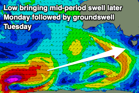
Into next week we've got an active week of surf thanks to strong low forming in the Heard Island region, projecting east and then being followed up by secondary polar frontal activity.
The initial polar low should generate a fetch of severe-gale to storm-force W/SW winds and a good sized W/SW groundswell for Tuesday, peaking into the afternoon. Ahead of this some small, mid-period W/SW swell should reach 1-2ft Monday afternoon but with onshore winds, with the groundswell hitting 2ft+ Tuesday afternoon with NW tending SE winds.
A trough may bring another change on Wednesday as the swell eases, with some reinforcing swell from the trailing activity due late Friday but more so Saturday. More on this in Friday's update.