Lots of swell for next week but with generally average winds

Victorian Surf Forecast by Craig Brokensha (issued Friday 27th January)
Best Days: This morning exposed beaches, tomorrow exposed beaches ahead of the sea breeze, Wednesday morning Surf Coast
Features of the Forecast (tl;dr)
- Fading swell tomorrow with strong N/NE winds, easing early PM ahead of S/SE sea breezes
- Tiny Sun with variable tending fresh S/SW-S/SE winds
- Moderate sized mid-period SW swell building Mon with mod-fresh S-S/SW winds
- Swell holding Tue with similar mod-fresh S-S/SW winds
- Inconsistent SW groundswell for later Tue, and Wed AM, then easing
- Moderate W/NW winds Wed AM ahead of a mod-fresh S/SW change later AM
- Moderate sized + mid-period SW swell Fri with winds unsure
Recap
Clean conditions across the Surf Coast yesterday morning with an inconsistent groundswell to 2ft to occasionally 3ft, with workable waves to 4ft to the east. A gusty onshore change moved in mid-morning, creating poor conditions for the rest of the day.
This morning winds have quickly shifted around to the east, cleaning up the beaches with a peak in mid-period swells to 3ft on the Surf Coast magnets and 3-5ft to the east. Winds should tend lighter E/NE to the east this morning before sea breezes kick in midday/early afternoon. With this the beaches should remain fun until early afternoon.


Some spots are cleaner than others this AM
This weekend and next week (Jan 28 – Feb 3)
The current mix of mid-period W/SW swells will ease through tomorrow under strong and tricky N/NE winds as a trough approaches from the west. Winds are due to ease into the early afternoon as the trough weakens on approach, with S/SE sea breezes likely to override any change from the S/SW.
Easing 1-2ft sets are due on the Surf Coast, not great at all on the early morning high tide, with dropping sets from 3ft to the east. Later morning looks best (but smaller) as winds ease.
Due to the weak nature of the trough we're now looking at a small window of variable winds Sunday morning (though with no swell) before winds freshen from the S/SW as high moves in from the west, tending S/SE into the afternoon and becoming a little stronger.
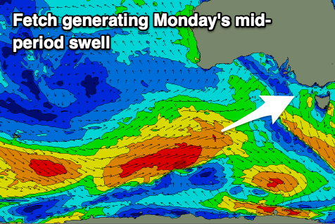
Monday looks to be another lay day with moderate to fresh S-S/SW winds lingering across the coast with a moderate sized mid-period SW swell due to build through the day.
This swell and a reinforcing groundswell for later Tuesday, easing Wednesday are being generated by a strong polar low that's formed in the Heard Island region.
Initially a fetch severe-gale W/SW winds were generated, with the low now racing ahead of the swell produced by this fetch, generating additional strong to gale-force W/SW winds while projecting east-northeast under WA.
The bulk of the swell is now due into Monday afternoon and Tuesday morning with good 4ft surf due on the Surf Coast, 6ft to the east but with those poor southerly winds, lingering into Tuesday.

The less consistent groundswell should come in around a similar size later Tuesday and Wednesday morning before easing and we should see a window of W/NW winds ahead of a shallow S/SW change later morning.
This is the window (Wednesday) to hit with the incoming swell.
Following the strong low, a healthy polar frontal progression should generate some moderate sized, reinforcing mid-period swell for Friday. Easy 4ft sets are due on the Surf Coast and 6ft surf to the east (likely a touch bigger) though winds are unsure. They hang on a secondary polar front projecting up towards us later week, so check back here on Monday for a clearer idea. The low itself will bring plenty of additional swell but winds are the main issue. Have a great weekend!